World Map with Major Latitude Circles
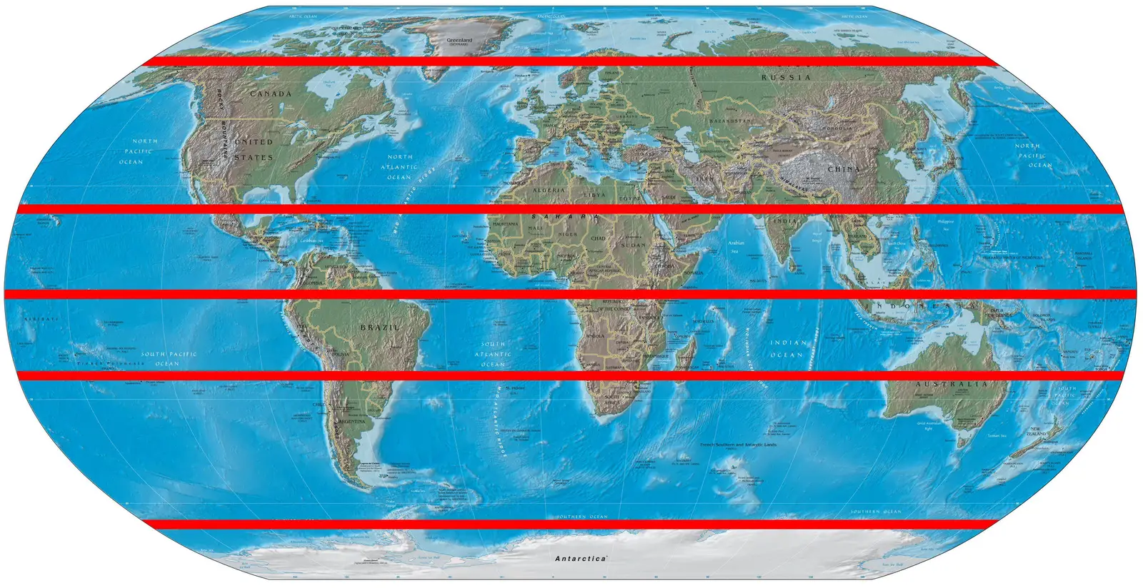
Click or tap the map to enlarge it.
Key Takeaways
- World Map With Major Latitude Circles showcases the major lines of latitude that divide the Earth into distinct regions.
- This map provides valuable information about the geographical features, climate patterns, and time zones of different areas.
- Understanding the latitude circles helps in navigation, determining distances, and analyzing climate variations around the globe.
History
The concept of latitude circles dates back to ancient times when astronomers and navigators began observing the Earth and its characteristics. One of the earliest mentions of latitude can be found in the works of the ancient Greek philosopher and mathematician, Eratosthenes. He was the first known person to measure the Earth’s circumference and divided the globe into 60 degrees of latitude. Later, this division was refined by Claudius Ptolemy, an Alexandrian geographer, who introduced the concept of equator, tropics, and polar circles.
During the Age of Discovery, renowned explorers such as Christopher Columbus, Ferdinand Magellan, and James Cook utilized latitude circles to navigate through uncharted territories. Latitude circles provided a fundamental framework for calculating distances, determining direction, and locating important landmarks.
Unique Insights
1. Significance of Equator: The equator is the most prominent line of latitude and divides the Earth into the Northern and Southern Hemispheres. It has a major impact on the climate and biodiversity of different regions. Countries near the equator experience tropical climates with abundant rainfall, while regions farther away from the equator have distinct seasons.
2. Tropics and Subtropics: The Tropic of Cancer and the Tropic of Capricorn are important latitude circles that mark the northernmost and southernmost points where the sun appears directly overhead. These regions are known for their warm weather and unique ecosystems. The Subtropical Zones lie between the tropics and the mid-latitudes, displaying characteristics of both these regions.
3. Polar Circles and the Poles: The Arctic Circle and the Antarctic Circle mark the southernmost and northernmost points at which the sun remains visible or invisible for 24 hours during the summer and winter solstices. These extreme regions are characterized by freezing temperatures, polar ice caps, and unique wildlife.
Table of Relevant Facts
| Latitude Circle | Location | Corresponding Position |
|---|---|---|
| Equator | Around the middle of the Earth | 0° latitude |
| Tropic of Cancer | Approximately 23.5° north of the Equator | 23.5° latitude |
| Tropic of Capricorn | Approximately 23.5° south of the Equator | 23.5° latitude |
| Arctic Circle | 66.5° north of the Equator | 66.5° latitude |
| Antarctic Circle | 66.5° south of the Equator | 66.5° latitude |
FAQ
-
What is the purpose of latitude circles?
Latitude circles help in defining the geographical location of a place and aid in navigation, determining distances, and understanding climate patterns.
-
How many latitude circles are there?
There are five major latitude circles: the Equator, the Tropic of Cancer, the Tropic of Capricorn, the Arctic Circle, and the Antarctic Circle.
-
What happens at the Arctic and Antarctic Circles?
During the summer and winter solstices, the sun remains visible for 24 hours within the Arctic Circle and invisible within the Antarctic Circle.
-
What is the significance of the Tropics?
The Tropics (Tropic of Cancer and Tropic of Capricorn) receive direct sunlight throughout the year, resulting in warm temperatures and unique ecosystems.
-
How does the Equator affect climate?
The proximity to the Equator influences climate, as regions near to it experience tropical climates, while those farther away have distinct seasons.
-
What is the latitude of the North Pole?
The latitude of the North Pole is 90° north.
-
What is the latitude of the South Pole?
The latitude of the South Pole is 90° south.