Badamichalukyaempire Map
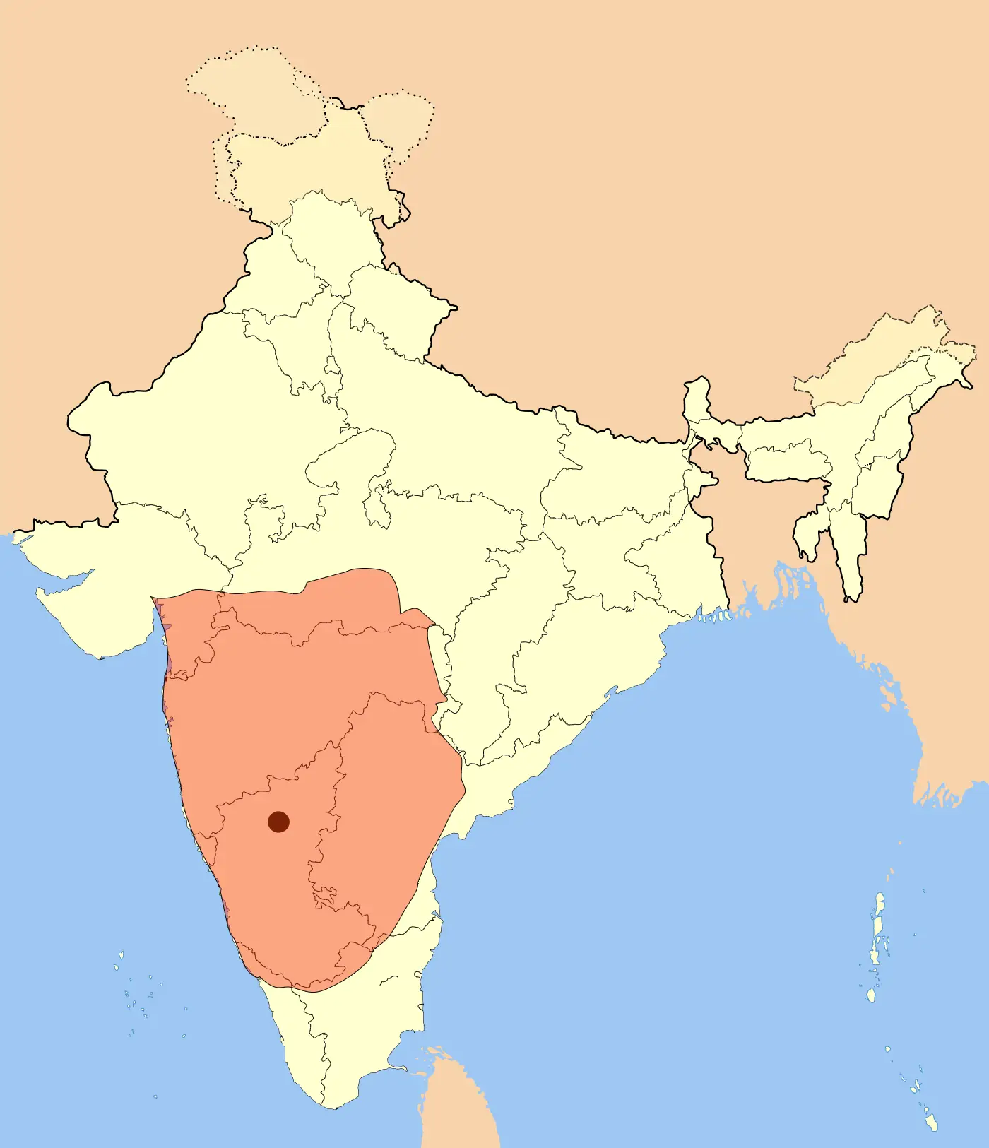
Click or tap the map to enlarge it.
The Badami Chalukya Empire Map – A Glorious Journey Through History
Key Takeaways
- The Badami Chalukya Empire was a significant medieval Indian dynasty.
- Their empire flourished between the 6th and 8th centuries CE in the Deccan region of South India.
- The Badami Chalukya Empire was known for its architectural marvels and patronage of the arts.
- Exploring the Badami Chalukya Empire’s map offers insights into their territorial extent and cultural influence.
History of the Badami Chalukya Empire
The Badami Chalukya Empire, also referred to as the Early Chalukyas, was a powerful dynasty that ruled over parts of present-day Karnataka and Andhra Pradesh in India. The empire rose to prominence in the 6th century CE, with its capital situated in the magnificent city of Badami.
The founding ruler of the Badami Chalukya dynasty was King Pulakeshin I. Under his reign, the empire experienced significant territorial expansions through military conquests and diplomatic alliances. The empire reached its zenith of glory under the rule of Pulakeshin II, who not only expanded the empire’s territory but also fostered a period of remarkable cultural and artistic achievements.
Unique Insights
Exploring the Badami Chalukya Empire’s map provides several unique insights into the civilization:
- The Badami Chalukyas were known for their exquisite rock-cut cave temples, which are prominent features on the map.
- Their empire comprised major regions such as Badami, Aihole, Pattadakal, and Mahakuta, each with its own architectural marvels.
- Artistic influences from different regions can be observed in the diverse architectural styles present in the empire.
- The empire’s strategic location facilitated trade and cultural exchanges with other kingdoms, leaving lasting influences on art, religion, and architecture.
- The Badami Chalukya Empire possessed a well-organized administrative system, as evident through their efficient governance and revenue administration.
Badami Chalukya Empire Map – Relevant Facts
| Fact | Date |
|---|---|
| The establishment of the Badami Chalukya Empire | 543 CE |
| Pulakeshin I becomes the first king | 543 CE |
| Pulakeshin II’s reign – height of power and cultural achievements | 610-642 CE |
| The empire’s decline begins | 8th century CE |
| End of the Badami Chalukya Empire | 757 CE |
Frequently Asked Questions (FAQ)
1. Which cities were significant within the Badami Chalukya Empire?
The Badami Chalukya Empire encompassed several prominent cities, with Badami, Aihole, Pattadakal, and Mahakuta being the most notable.
2. What architectural wonders were created by the Badami Chalukyas?
The Badami Chalukyas built remarkable rock-cut cave temples, intricate sculptures, elaborately carved pillars, and intricately designed shrines in their empire.
3. What impact did the Badami Chalukya Empire have on Indian art and architecture?
The Badami Chalukya Empire had a significant impact on Indian art and architecture. Their architectural innovations influenced future generations and laid the foundation for the development of temple architecture styles in South India.
4. How long did the Badami Chalukya Empire exist?
The Badami Chalukya Empire lasted from 543 CE to 757 CE, a span of approximately 214 years.
5. Who were the notable rulers of the Badami Chalukya Empire?
Kings Pulakeshin I and Pulakeshin II were the most notable rulers of the Badami Chalukya Empire. They played significant roles in expanding the empire’s territory and patronizing the arts.
6. What led to the decline of the Badami Chalukya Empire?
The decline of the Badami Chalukya Empire can be attributed to various factors, including internal conflicts, external invasions, and the rise of other regional powers.
7. Are the architectural remnants of the Badami Chalukya Empire still present today?
Yes, many architectural wonders built by the Badami Chalukyas, such as the Badami Cave Temples and the temples of Aihole and Pattadakal, still exist and are popular tourist attractions.