Map of 1893 Worlds Columbian Exposition by Rand Mcnally
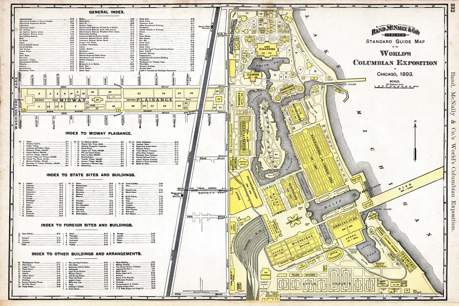
Click or tap the map to enlarge it.
Key Takeaways
- The map of the 1893 World’s Columbian Exposition by Rand McNally provides valuable insights into the layout and structure of the historic grand fair.
- It showcases the remarkable attention to detail and accuracy of Rand McNally, a renowned cartographic company.
- The map serves as a visual representation of the Exposition’s various buildings, landscapes, and attractions, allowing us to retrace history.
- By studying this map, we can understand the significance and impact of the World’s Columbian Exposition on the socio-cultural and architectural landscape of Chicago.
- It offers a glimpse into the past and helps us appreciate the efforts put into organizing such a monumental event.
History
The 1893 World’s Columbian Exposition, held in Chicago, Illinois, was a milestone event to commemorate the 400th anniversary of Christopher Columbus’ arrival in America. Spanning over 600 acres, the fair boasted elaborate architectures, captivating exhibits, and technological advancements of the time.
Rand McNally, a prominent mapmaking company founded in Chicago, was commissioned to create a detailed map of the Exposition. Published in 1892, the map was an impressive cartographic achievement, capturing the essence of the fair and accurately depicting its structural layout.
Unique Insights
The map of the 1893 World’s Columbian Exposition by Rand McNally offers unique insights into the fair. Here are some notable observations:
1. Comprehensive Architectural Representation
The map meticulously illustrates the various pavilions, galleries, and structures that constituted the Exposition. Each building is accurately depicted, showcasing the intricate architectural designs and styles of the era. This comprehensive representation allows us to imagine the grandeur and diversity of the fair.
2. Landscapes and Water Features
In addition to the buildings, the map also portrays the landscapes and water features within the fairgrounds. It highlights the lagoons, canals, and artificial islands created specifically for the event. This insight gives us a sense of the careful planning and attention to detail that went into constructing the Exposition.
3. Transportation Infrastructure
Rand McNally’s map provides an overview of the transportation infrastructure implemented for the fair. It displays the network of roads, railways, and bridges connecting different parts of the Exposition. This insight reveals the logistical challenges faced and the innovative solutions implemented to accommodate the massive influx of visitors.
Table of Relevant Facts
| Date | Event |
|---|---|
| May 1, 1893 | Opening Day of the World’s Columbian Exposition |
| October 30, 1893 | Closing Day of the World’s Columbian Exposition |
| 27 Million | Estimated Number of Visitors |
| Chicago | Host City of the Exposition |
Frequently Asked Questions (FAQ)
-
What was the purpose of the 1893 World’s Columbian Exposition?
The purpose of the 1893 World’s Columbian Exposition was to celebrate the 400th anniversary of Christopher Columbus’ arrival in America and showcase advancements in various fields.
-
Who commissioned Rand McNally to create the map of the Exposition?
Rand McNally was commissioned by the organizers of the Exposition to create a detailed and accurate map of the fair.
-
What does the map illustrate apart from just the buildings?
The map also illustrates the landscapes, water features, and transportation infrastructure within the fairgrounds.
-
How accurate is Rand McNally’s map?
Rand McNally’s map is known for its extraordinary accuracy in depicting the architectural layouts and details of the World’s Columbian Exposition.
-
How long did the Exposition last?
The World’s Columbian Exposition lasted from May 1, 1893, to October 30, 1983 – a total of six months and twenty-nine days.
-
How many visitors attended the Exposition?
An estimated 27 million visitors attended the World’s Columbian Exposition during its duration.
-
What was the significance of the Exposition?
The Exposition showcased technological advancements, cultural diversity, and architectural marvels, leaving a lasting impact on Chicago’s landscape and influencing future fair designs.