Battle of Aleppo Map
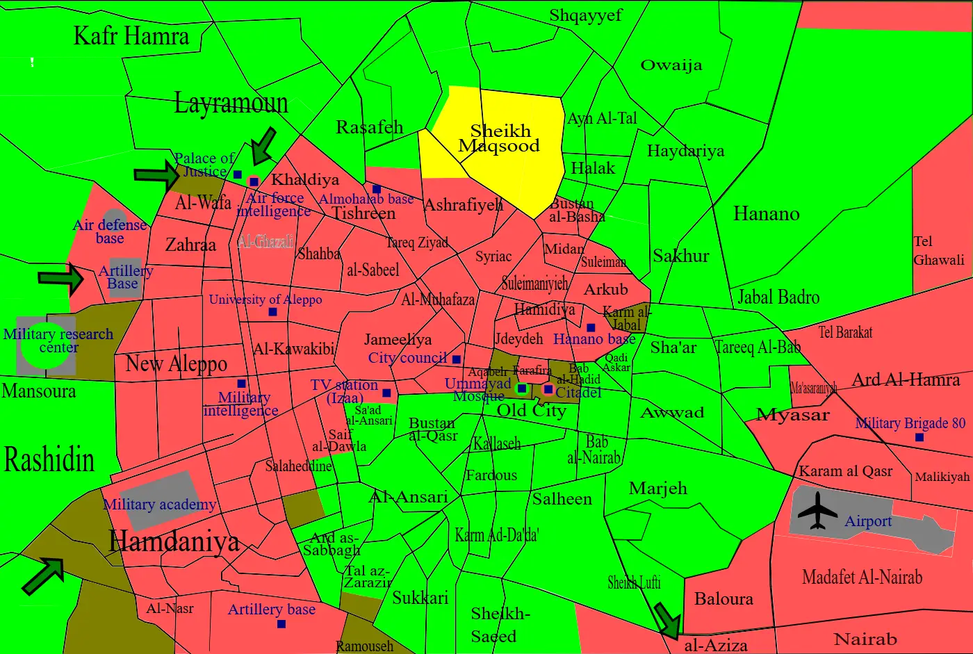
Click or tap the map to enlarge it.
Battle Of Aleppo Map – A Detailed Overview
Key Takeaways
- The Battle of Aleppo was a major conflict in the Syrian Civil War.
- A detailed map can provide valuable insights into the geographical and strategic aspects of the battle.
- Aleppo, a historical city in northern Syria, witnessed intense fighting between different factions during the battle.
- The outcome of the battle had a significant impact on the overall dynamics of the Syrian Civil War.
History
The Battle of Aleppo, which took place between 2012 and 2016, was one of the longest and most intense battles of the Syrian Civil War. This battle was fought primarily between the Syrian government forces and various opposition factions seeking to seize control of Aleppo, a city of great strategic importance in northern Syria.
The conflict in Aleppo can be traced back to early 2012 when anti-government protests escalated into armed confrontations. Over time, the city became divided between government-held sectors and those controlled by opposition forces. The battle saw significant damage to infrastructure, loss of civilian lives, and triggered a massive humanitarian crisis.
Unique Insights
Studying the map of the Battle of Aleppo provides several unique insights into the dynamics of the conflict:
- The ring of fortified military bases around Aleppo acted as strongholds for the government forces, allowing them to maintain control over certain strategic areas.
- The rebel-held eastern part of the city was under siege by government forces for a prolonged period, resulting in a humanitarian crisis.
- Various opposition factions, including the Free Syrian Army and Islamist militant groups, were involved in the battle, each controlling different parts of the city at different times.
- The battle witnessed multiple shifting frontlines, indicating the fluid nature of the conflict and the challenges faced by both sides in maintaining territorial control.
Aleppo Map – Facts and Figures
| Date | Significant Event |
|---|---|
| 2012 | Rebel factions seize parts of eastern Aleppo |
| 2013 | The government regains control of key areas in Aleppo |
| 2014 | The Islamic State (IS) gains control of large parts of eastern Aleppo |
| 2016 | Government forces reclaim the entire city of Aleppo |
Frequently Asked Questions (FAQ)
-
Q: What caused the Battle of Aleppo?
A: The Battle of Aleppo was primarily caused by the ongoing Syrian Civil War, where multiple factions vied for control over the country.
-
Q: What were the consequences of the Battle of Aleppo?
A: The Battle of Aleppo led to widespread destruction, loss of lives, and a significant shift in the balance of power within the Syrian Civil War.
-
Q: How did the Battle of Aleppo impact the local population?
A: The local population in Aleppo suffered immensely during the battle, with thousands of civilians losing their lives and many others being displaced.
-
Q: Which factions were involved in the battle?
A: The battle involved several factions, including the Syrian government forces, rebel groups, and Islamist militant organizations.
-
Q: How long did the Battle of Aleppo last?
A: The battle lasted for approximately four years, from 2012 to 2016.
-
Q: Was the Battle of Aleppo strategically important?
A: Yes, Aleppo was a strategically important city due to its location and economic significance.
-
Q: Who ultimately gained control over Aleppo?
A: The Syrian government forces ultimately regained full control over the city of Aleppo.
External Links
LSI Keywords
- Battle of Aleppo map
- Aleppo conflict
- Syrian Civil War
- Government forces
- Opposition factions
- Strategic importance
- Ring of fortified military bases
- Shift in balance of power
- Humanitarian crisis
- Territorial control