Canada Regions Map
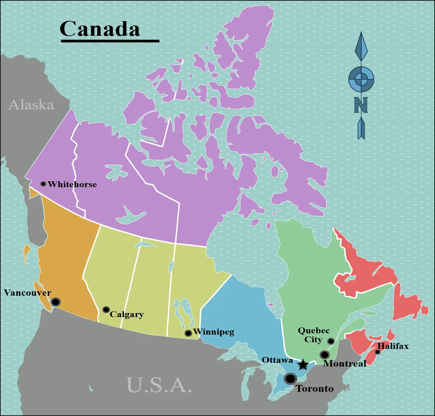
Click or tap the map to enlarge it.
Canada Regions Map – An Expert Cartographer’s Overview
Key Takeaways
- Canada is divided into ten provinces and three territories.
- The geography of Canada is diverse and includes vast forests, mountains, and coastlines.
- The regions of Canada, such as Atlantic Canada, Central Canada, and Western Canada, each have unique characteristics.
- Understanding the regions of Canada is essential for exploring its diverse culture, history, and natural beauty.
History
Canada, the second-largest country in the world, has a rich and diverse history that has shaped the current regions we see on the map today. Indigenous peoples have inhabited the land for thousands of years, followed by various European explorations and settlements in the 15th century.
Over the centuries, Canada experienced conflicts, colonialism, and eventual independence, leading to the establishment of its provinces and territories. The current map of Canada’s regions reflects the historical developments and cultural influences throughout its past.
Unique Insights
- The Atlantic Canada region consists of four provinces, namely Newfoundland and Labrador, Prince Edward Island, Nova Scotia, and New Brunswick. It is known for its stunning coastal beauty, friendly people, and vibrant fishing communities.
- Central Canada comprises two provinces, Quebec and Ontario, and is home to Canada’s largest cities, including Toronto, Montreal, and Ottawa. This region is known for its rich cultural heritage, vibrant arts scene, and diverse population.
- Western Canada, consisting of British Columbia, Alberta, Saskatchewan, and Manitoba, is renowned for its breathtaking landscapes, including the Rocky Mountains, picturesque coastlines, and vast prairies. It is a popular destination for outdoor enthusiasts and offers a high quality of life.
- The Northern Territories of Canada, namely Yukon, Northwest Territories, and Nunavut, are sparsely populated and feature unique Arctic landscapes, indigenous cultures, and opportunities for adventure.
- Each region of Canada has its own distinct climate, flora, and fauna, adding to the country’s natural diversity.
- Indigenous traditions and cultures play a significant role in the regions of Canada, contributing to its overall cultural fabric.
Relevant Facts
| Year | Event |
|---|---|
| 1534 | French explorer Jacques Cartier lays claim to Canada |
| 1867 | Confederation of Canada; Dominion of Canada is established |
| 1870 | Manitoba becomes Canada’s fifth province |
| 1949 | Newfoundland becomes Canada’s tenth province |
| 1999 | Nunavut becomes a separate territory |
Frequently Asked Questions
-
What are the ten provinces of Canada?
The ten provinces of Canada are British Columbia, Alberta, Saskatchewan, Manitoba, Ontario, Quebec, New Brunswick, Prince Edward Island, Nova Scotia, and Newfoundland and Labrador.
-
What are the three territories of Canada?
The three territories of Canada are Yukon, Northwest Territories, and Nunavut.
-
Which region of Canada is known for its coastal beauty?
Atlantic Canada is known for its stunning coastal beauty.
-
Which region of Canada is home to the largest cities?
Central Canada, specifically Ontario and Quebec, is home to Canada’s largest cities.
-
What is unique about Western Canada?
Western Canada is renowned for its breathtaking landscapes, including the Rocky Mountains and picturesque coastlines.
-
Which year was Newfoundland established as a province?
Newfoundland became Canada’s tenth province in 1949.
-
When did Nunavut become a separate territory?
Nunavut became a separate territory in 1999.
External Links
LSI Keywords
- Map of Canada
- Canadian regions
- Provinces and territories
- Geography of Canada
- Central Canada
- Atlantic Canada
- Western Canada
- Northern Territories
- Canadian history
- Indigenous cultures
- Canada’s natural diversity