Chihuahua Mexico Map
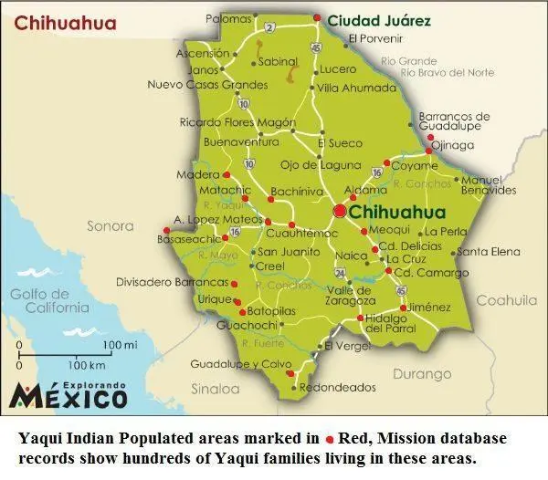
Click or tap the map to enlarge it.
Chihuahua Mexico Map – Key Takeaways
- Chihuahua is the largest state in Mexico.
- Chihuahua is known for its diverse geography, spanning from the Sierra Madre Occidental mountain range to the Chihuahuan Desert.
- The state offers various attractions, including natural parks, historic sites, and vibrant cities.
- Chihuahua Mexico Map provides a detailed representation of the state’s major cities, highways, and geographical features.
- The map serves as a useful tool for travelers, researchers, and anyone interested in exploring Chihuahua.
History of Chihuahua
Chihuahua, the largest state in Mexico, is a region steeped in history. Before the arrival of the Spanish, the area was inhabited by various indigenous tribes, including the Tarahumara and Conchos. In the 16th century, the Spanish conquistadors arrived and established settlements, bringing their culture and European influence to the region.
Chihuahua played a significant role in Mexico’s struggle for independence in the early 19th century. The city of Chihuahua, the state’s capital, became a center for revolutionary activities. It was here that Miguel Hidalgo, a key figure in the Mexican War of Independence, was imprisoned before his execution in 1811.
The state’s history is also closely tied to the Mexican Revolution, which took place from 1910 to 1920. Chihuahua witnessed major battles and saw the rise of key revolutionary leaders, including Pancho Villa. Today, visitors can explore important historical sites that serve as reminders of these significant events.
Unique Insights
The Chihuahua Mexico Map offers unique insights into the state’s diverse geography. The map showcases the Sierra Madre Occidental, a mountain range that runs through the state, providing breathtaking views and opportunities for outdoor activities such as hiking and mountain biking. The Chihuahuan Desert, one of the largest deserts in North America, is also highlighted on the map, allowing travelers to appreciate its beauty and unique ecosystem.
Additionally, the map features the city of Chihuahua, known for its rich colonial architecture and historical sites. Visitors can explore the stunning Cathedral of Chihuahua, the Casa Chihuahua Cultural Center, and the Pancho Villa Museum, which provides a deeper understanding of the state’s revolutionary past.
Another remarkable feature displayed on the Chihuahua Mexico Map is Copper Canyon, a sprawling series of canyons larger and deeper than the Grand Canyon in the United States. Travelers can embark on a scenic train ride through the canyon or hike along its trails, marveling at the sheer beauty of the natural landscape.
Table of Relevant Facts
| Year | Event |
|---|---|
| 16th century | Spanish conquistadors arrive in Chihuahua |
| 1811 | Miguel Hidalgo executed in Chihuahua |
| 1910-1920 | Mexican Revolution |
| Present | Copper Canyon is a popular tourist attraction |
Frequently Asked Questions
1. What are the main cities in Chihuahua?
The main cities in Chihuahua include Chihuahua City, Ciudad Juarez, Delicias, and Cuauhtémoc.
2. What are the popular natural parks to visit in Chihuahua?
Some of the popular natural parks in Chihuahua are Cumbres de Majalca National Park, Basaseachi National Park, and Copper Canyon.
3. How can I explore Copper Canyon?
You can explore Copper Canyon by taking a scenic train ride, hiking, or joining guided tours.
4. What historical sites are worth visiting in Chihuahua City?
Some of the notable historical sites in Chihuahua City are the Cathedral of Chihuahua, the Casa Chihuahua Cultural Center, and the Pancho Villa Museum.
5. What is the climate like in Chihuahua?
Chihuahua has a semi-arid climate with hot summers and cool winters. The temperature can vary significantly between day and night.
6. Are there any UNESCO World Heritage Sites in Chihuahua?
Yes, there is one UNESCO World Heritage Site in Chihuahua, namely the rock art in the Sierra de San Francisco region.
7. How safe is it to travel to Chihuahua?
While Chihuahua is generally safe for tourists, it is always recommended to stay informed about local conditions and follow the advice of authorities.