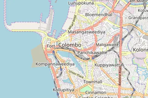
Colombo District Location Map
Colombo District Location Map
Key Takeaways
- The Colombo District Location Map provides a comprehensive overview of the geographical boundaries of the Colombo District in Sri Lanka.
- It showcases the major cities, towns, and landmarks within the district.
- The map offers valuable insights for tourists, researchers, and individuals looking to explore or understand the region better.
History
The Colombo District is located on the western coast of Sri Lanka and is home to the country’s capital city, Colombo. This district holds great historical significance, serving as a hub for trade and commerce for centuries.
Colombo has been a key port city since ancient times due to its strategic location along the renowned Silk Road. It connected Asia with Europe and attracted traders from various nations. Over centuries, the city witnessed the influence of diverse cultures, including Indian, Arab, Portuguese, Dutch, and finally British colonial forces.
With Sri Lanka gaining independence in 1948, Colombo became the administrative center and the commercial capital of the nation. Today, it stands as a bustling metropolis and the primary economic hub of the country.
Unique Insights
- The Colombo District is renowned for its vibrant cultural heritage, reflected in its historical landmarks, museums, and diverse architecture.
- The district comprises major tourist attractions, including the Galle Face Green, Colombo National Museum, Gangaramaya Temple, and Independence Memorial Hall.
- Colombo features a significant number of parks and green spaces, such as Viharamahadevi Park and the Diyatha Uyana Urban Wetland Park.
- The Colombo District encompasses diverse neighborhoods, each with its own distinct character and attractions, such as Fort, Pettah, and Mount Lavinia.
About the Colombo District Location Map
The Colombo District Location Map offers a comprehensive visual representation of the district, outlining its boundaries, major cities, towns, and key geographical features. It provides an excellent resource for locals and visitors to explore the region.
Table: Key Facts of Colombo District
| Fact | Description |
|---|---|
| Total Area | 699 square kilometers |
| Population | Approximately 2.5 million |
| Main City | Colombo |
| Significant Landmarks | Gangaramaya Temple, Colombo National Museum, Galle Face Green |
Frequently Asked Questions (FAQ)
-
What is the significance of Colombo District?
The Colombo District serves as the administrative and commercial capital of Sri Lanka. It has a rich historical heritage and is a major tourist attraction.
-
What are some popular landmarks within the Colombo District?
Some popular landmarks in the Colombo District include the Gangaramaya Temple, Colombo National Museum, Galle Face Green, and Independence Memorial Hall.
-
Are there any parks or green spaces in the district?
Yes, the Colombo District features several parks and green spaces, such as Viharamahadevi Park and the Diyatha Uyana Urban Wetland Park.
-
Which neighborhoods should I explore in Colombo?
Fort, Pettah, and Mount Lavinia are some of the diverse and vibrant neighborhoods in the Colombo District that are worth exploring.
-
How can I access the Colombo District Location Map?
The Colombo District Location Map is easily accessible online through various mapping platforms and tourist websites.
-
Can I find historical information and artifacts in the Colombo National Museum?
Yes, the Colombo National Museum is a treasure trove of historical artifacts and provides comprehensive historical information about Sri Lanka.
-
What is the total area of the Colombo District?
The Colombo District spans approximately 699 square kilometers.