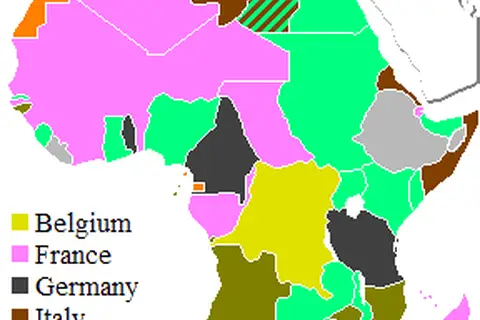
Colonial Map of Africa in 1930
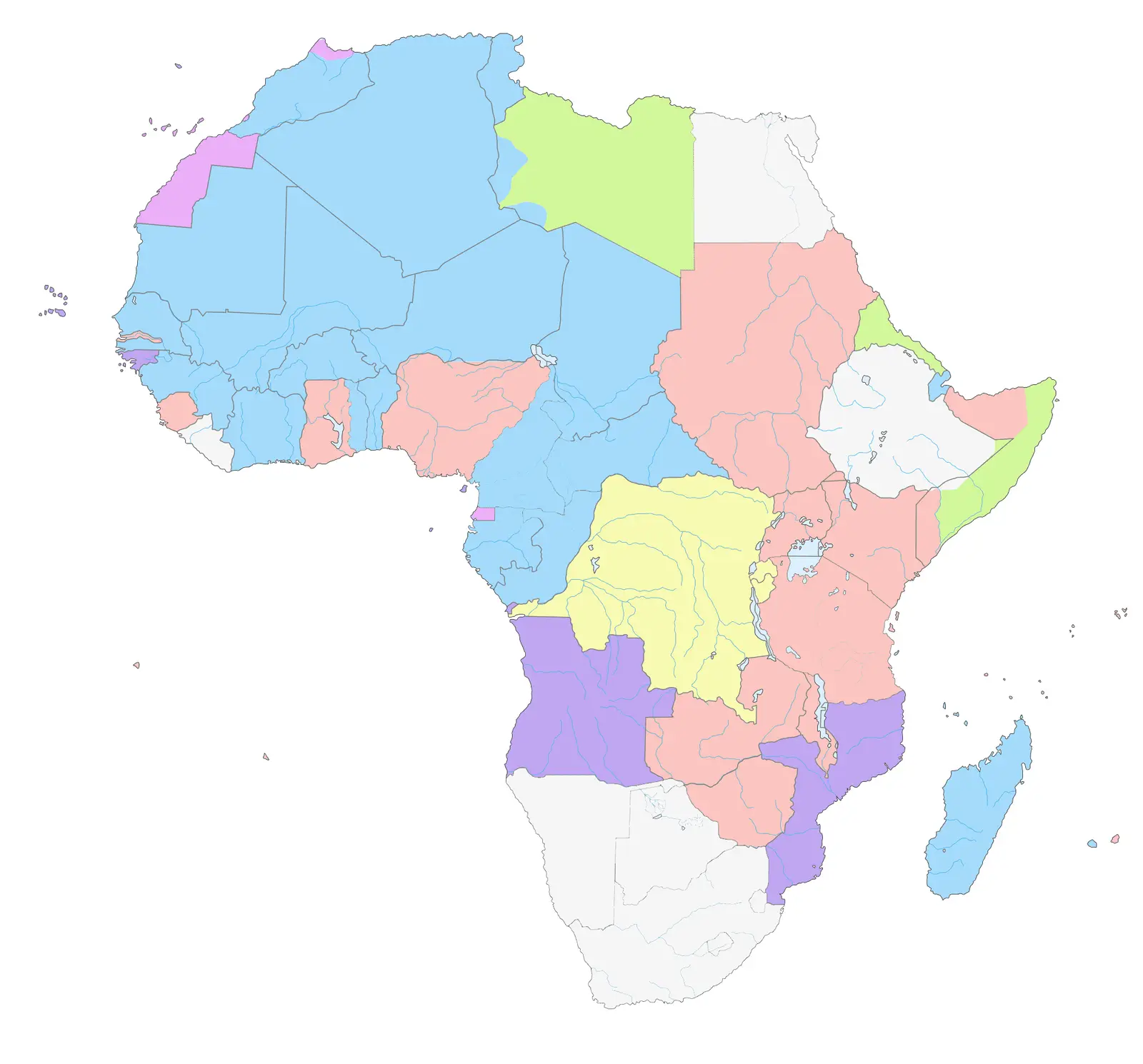
Click or tap the map to enlarge it.
Key Takeaways
- A colonial map of Africa in 1930 provides insights into the historical presence and influence of various European powers.
- It showcases the territorial divisions imposed by colonialism and its impact on African nations.
- This map serves as a reminder of the colonial era’s long-lasting effects on the African continent.
History
In the late 19th and early 20th centuries, the European powers embarked on a quest for colonization, dividing Africa among themselves. By 1930, Africa had undergone significant changes due to this colonial expansion.
The colonial map of Africa in 1930 illustrates the territories controlled by various European nations. It highlights a significant period in African history that shaped the continent politically, socially, and economically.
Unique Insights
Examining the colonial map of Africa in 1930 provides several unique insights:
- Africa was almost entirely colonized by European powers, except for Liberia and Ethiopia, which remained independent.
- Colonial boundaries were often drawn haphazardly, disregarding indigenous ethnic groups, leading to conflicts and instability in later years.
- The map showcases the dominance of major powers such as Britain, France, Germany, Italy, Portugal, Spain, and Belgium, with each exerting control over different territories.
- The borders imposed by colonial powers divided ethnic groups, resulting in ongoing tensions in modern-day African nations.
Table of Relevant Facts in 1930
| European Power | Colonial Territories in Africa |
|---|---|
| Britain | Egypt, Sudan, South Africa, Nigeria, Kenya, Rhodesia, and more |
| France | Algeria, French West Africa, French Equatorial Africa, Madagascar, and more |
| Germany | German East Africa, German Southwest Africa, Togoland, and more |
| Italy | Italian Libya, Italian East Africa, Italian Somaliland, and more |
| Portugal | Angola, Mozambique, Portuguese Guinea, Portuguese East Africa, and more |
| Spain | Spanish Sahara, Spanish Guinea, Río de Oro, and more |
| Belgium | Belgian Congo |
Frequently Asked Questions (FAQ)
1. Why were African territories colonized in the 19th and 20th centuries?
African territories were colonized due to European powers’ economic interests, desire for resources, strategic advantages, and competition among the nations.
2. How did African nations resist colonization?
African nations resisted colonization through armed resistance, diplomatic efforts, and socio-cultural strategies aimed at maintaining independence.
3. What were the long-term effects of colonization in Africa?
Colonization led to the disruption of indigenous cultures, exploitation of resources, political instability, ethnic conflicts, and the legacy of uneven economic development.
4. Did any African nations maintain their independence in 1930?
Yes, Liberia and Ethiopia were the only African nations that remained independent during this period of intense colonization.
5. How did the arbitrary drawing of colonial boundaries impact African nations?
The arbitrary drawing of colonial boundaries divided ethnic groups, resulting in conflicts, disputes over resources, and the creation of multi-ethnic states with deeply rooted tensions.
6. What happened to colonial borders after African nations gained independence?
After African nations gained independence, the colonial borders remained largely intact, leading to the challenges of governing ethnically diverse countries.
7. How did the colonial era shape Africa’s relationship with Europe?
The colonial era deeply impacted Africa’s relationship with Europe, fostering a complex dynamic of historical, political, economic, and cultural ties that continue to shape the present.
External Links
LSI Keywords
- Colonial Africa
- European colonial powers
- Colonial territories
- Effects of colonization in Africa
- Boundaries in Africa
- African independence movements
- European-African relations