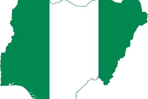
Flagmap of Nigeria
Key Takeaways
- The Flagmap of Nigeria represents the national flag of Nigeria embedded in its geographic shape.
- The flag consists of two vertical green stripes on the edges and a white stripe in the middle, symbolizing peace.
- This map is a unique representation that combines national identity with geographical context.
- Nigeria’s flag is rich in symbolism and holds significant cultural and historical importance.
- It is an important visual representation used in various contexts, such as education, patriotic displays, and official documents.
History of the Flagmap of Nigeria
The Flagmap of Nigeria is a visual representation that integrates the national flag of Nigeria into the shape of the country’s geographical outline. It is a unique and creative design that showcases the national flag within its geographic context.
The national flag of Nigeria was first designed in 1959 by a Nigerian student named Michael Taiwo Akinkunmi, who was studying in London at the time. The flag was officially hoisted for the first time on October 1, 1960, when Nigeria gained independence from British colonial rule. The green stripes on the flag represent Nigeria’s agricultural wealth, while the white stripe symbolizes peace.
Unique Insights
The Flagmap of Nigeria is significant because it combines national pride with geographical identity. It serves as a powerful symbol of unity and progress for the Nigerian people. The map is widely recognized and used in various official and unofficial contexts, including educational materials, government documents, and patriotic displays.
The Flagmap of Nigeria is not only visually appealing but also has profound cultural and historical significance. It represents Nigeria’s journey to independence and its commitment to peace and prosperity. The map is a reminder of the country’s rich heritage and diverse landscapes, reflecting its position as a major African nation.
Table of Relevant Facts
| Year | Event |
|---|---|
| 1959 | Michael Taiwo Akinkunmi designs the Nigerian national flag. |
| 1960 | Nigeria gains independence from British colonial rule, and the national flag is hoisted for the first time. |
Frequently Asked Questions (FAQ)
-
What does the Flagmap of Nigeria represent?
The Flagmap of Nigeria represents the national flag of Nigeria embedded in its geographic shape, combining national identity with geographical context.
-
Who designed the Nigerian national flag?
The national flag of Nigeria was designed by Michael Taiwo Akinkunmi, a Nigerian student studying in London at the time.
-
What do the colors on the Nigerian flag symbolize?
The two green stripes on the Nigerian flag represent Nigeria’s agricultural wealth, while the white stripe symbolizes peace.
-
When was the Nigerian national flag first hoisted?
The Nigerian national flag was officially hoisted for the first time on October 1, 1960, when Nigeria gained independence.
-
Where is the Flagmap of Nigeria used?
The Flagmap of Nigeria is used in various contexts, such as educational materials, government documents, and patriotic displays.
-
What is the cultural significance of the Flagmap of Nigeria?
The Flagmap of Nigeria represents Nigeria’s journey to independence and its commitment to peace and prosperity. It is a symbol of unity and progress for the Nigerian people.
-
Why is the Flagmap of Nigeria visually appealing?
The Flagmap of Nigeria’s unique design integrates the national flag into the country’s geographic shape, creating a visually appealing representation.