Niger River Map
The Niger River Map – Exploring the Lifeline of West Africa
Key Takeaways
- The Niger River is one of the major rivers in Africa, spanning over 4,180 kilometers.
- It is a vital source of water, transportation, and livelihood for the countries it flows through.
- The Niger River Basin covers a diverse range of ecosystems and supports rich biodiversity.
- The river has played a significant role in the history and development of West Africa.
- Exploring the Niger River map provides valuable insights into the region’s geography and resources.
History
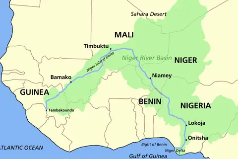
The Niger River, also known as Joliba or Egerew N-Igerewen in local languages, has served as a lifeline for West Africa for centuries. Its origins can be traced to the Guinea Highlands in southeastern Guinea. From there, it meanders through Mali, Niger, Benin, and Nigeria before flowing into the Gulf of Guinea. The river passes through diverse landscapes, including savannahs, wetlands, and arid regions, making it a unique and valuable ecosystem.
The Niger River has been a crucial trade route, facilitating cultural exchanges and economic activities in the region. Ancient civilizations, such as the Mali Empire, Songhai Empire, and various medieval African states, flourished along its banks. These civilizations greatly depended on the river for agriculture, irrigation, transportation, and trade, which contributed to the development of West Africa as a vibrant and prosperous region.
European explorers, including Mungo Park, René Caillié, and Heinrich Barth, ventured into the heart of Africa to discover the source of the Niger River. Their discoveries expanded the knowledge of the river’s course and its significance to the African continent. In the 19th century, European powers established colonial control over the Niger River Basin, exploiting its resources for economic gains.
Unique Insights
- The Niger River is the third-longest river in Africa after the Nile and the Congo.
- It forms a unique “L” shape, with the upper Niger River running southwest and the lower Niger River flowing southeast.
- The River’s delta, known as the Niger Delta, is a vast wetland and a hotspot of biodiversity.
- The Niger River is home to various aquatic species, including Nile crocodiles, hippopotamuses, catfish, and tilapia.
- Timbuktu, a historically significant city in Mali, is located near the Niger River and was an important trading center in ancient times.
Relevant Facts
| Year | Event |
|---|---|
| 13th century | The Mali Empire, one of the wealthiest and most powerful empires in West Africa, was at its peak. |
| 1468 | Rene Caillié, a French explorer, became the first European to reach the city of Timbuktu. |
| 1854-1855 | Heinrich Barth, a German explorer, completed a four-year journey from Tripoli to Timbuktu, documenting valuable information about the Niger River. |
| 1900s | The river became an important transportation route for European colonial powers who exploited its resources. |
FAQ
1. How long is the Niger River?
The Niger River spans over 4,180 kilometers, making it one of the longest rivers in Africa.
2. Which countries does the Niger River flow through?
The Niger River flows through Guinea, Mali, Niger, Benin, and Nigeria.
3. What is the Niger Delta?
The Niger Delta is the river’s delta region, located in Nigeria. It is a vast wetland known for its rich biodiversity.
4. Is the Niger River commercially significant?
Yes, the Niger River serves as a major transportation route, supporting economic activities and trade in the region.
5. Are there any historical sites along the Niger River?
Yes, the city of Timbuktu in Mali, located near the Niger River, is known for its historical significance as a center of trade and learning.
6. What wildlife can be found in the Niger River?
The Niger River is home to a diverse range of aquatic species, including Nile crocodiles, hippopotamuses, catfish, and tilapia.
7. How has the Niger River influenced the development of West Africa?
The Niger River has been instrumental in the development of West Africa, providing water for agriculture, transportation routes, and facilitating trade and cultural exchanges.