Guide Map of Golkonda Fort
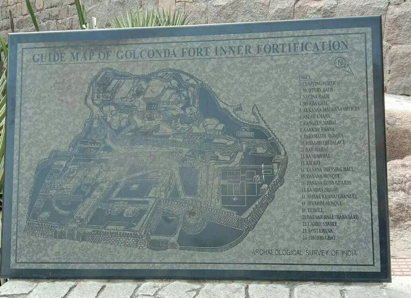
Click or tap the map to enlarge it.
Guide Map Of Golkonda Fort – The Ultimate Cartographer’s Guide
Key Takeaways
- Golkonda Fort is a historic fortress located in Hyderabad, Telangana, India.
- The fort offers stunning architecture, intriguing history, and breathtaking views.
- Exploring Golkonda Fort allows visitors to step back in time and experience the grandeur of an ancient civilization.
- The map of Golkonda Fort provides detailed information about the layout and key attractions within the fort.
- Golkonda Fort is a must-visit destination for history enthusiasts and architecture lovers.
History
Golkonda Fort, also known as the “Round Diamond Fort,” is a majestic fortress that dates back to the 13th century. Originally built by the Kakatiya Dynasty kings, it was later fortified by the Qutb Shahi Kings and served as the capital of the ancient Kingdom of Golkonda. The fort stood as a symbol of power and opulence under the Qutb Shahi dynasty until it was conquered by the Mughals in the late 17th century.
During its peak, Golkonda Fort was known for its flourishing diamond trade, which made it one of the wealthiest cities in the world. The economy of the region thrived due to its strategic location on major trade routes. The fort’s architecture is a blend of Hindu-Islamic styles, offering a unique visual experience.
Unique Insights
The strategic positioning of the Golkonda Fort on a granite hill provided a natural defense advantage, with massive fortification walls, gateways, and moats protecting the inner city. The fort was designed to withstand enemy attacks and had an advanced water supply system that ensured its inhabitants had a constant water supply even during sieges.
Golkonda Fort is home to several notable structures, including the impressive Fateh Darwaza (Victory Gate), Ibrahim Mosque, Toli Masjid, and a network of underground passages for communication and escape. Visitors can marvel at the ingenious acoustics of the fort, where handclaps near specific entry points can be heard on the topmost pavilions, ensuring a secure environment.
Table of Relevant Facts
| Year | Event |
|---|---|
| 13th Century | Original construction of Golkonda Fort by the Kakatiya Dynasty |
| 16th Century | Fortification and expansion under the Qutb Shahi Dynasty |
| 1687 | Mughal conquest of Golkonda Fort |
Frequently Asked Questions (FAQ)
1. How long does it take to explore Golkonda Fort?
Exploring Golkonda Fort usually takes around 2-3 hours, depending on your pace and interest in the historical details.
2. Are there guided tours available?
Yes, guided tours are available at Golkonda Fort. Certified guides provide insightful information about the fort’s history, architecture, and interesting anecdotes.
3. Are there any additional entry fees for attractions within the fort?
Yes, certain attractions within the fort may have separate entry fees. Visitors are advised to check the details at the entrance or with the tourist information center.
4. Can I take photographs inside the fort?
Photography is allowed within the fort premises. However, professional photography, including drones, may require special permission.
5. Is there a dress code to enter Golkonda Fort?
There is no strict dress code, but it is recommended to dress modestly and wear comfortable shoes as there will be walking involved.
6. Are there any restrictions for visiting the fort?
Currently, due to conservation efforts, certain areas of the fort might be restricted for visitors. Please follow the instructions at the fort regarding access to specific areas.
7. Is the fort accessible for individuals with mobility issues?
While some parts of the fort might have limited accessibility due to its historical nature, efforts have been made to improve accessibility to the main attractions. Wheelchair ramps and assistance are available at the entrance.