Himalayas Map
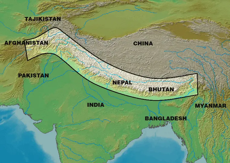
Click or tap the map to enlarge it.
Himalayas Map: Exploring the Majestic Mountain Range
Key Takeaways
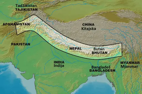
- The Himalayas is the highest and most extensive mountain range in the world, spanning several countries including India, Nepal, Bhutan, and Tibet.
- The Himalayas offer breathtaking landscapes, diverse flora and fauna, and numerous adventure opportunities for trekkers, climbers, and nature enthusiasts.
- Exploring the Himalayas requires thorough understanding of the terrain and careful planning, making a detailed map an essential tool for adventurers.
- A Himalayas map not only provides geographical information but also highlights important landmarks, trails, and altitudes to ensure a safe and enjoyable journey.
- Understanding the map symbols and legends is crucial for interpreting the terrain, routes, and other features represented on a Himalayas map.
History
The Himalayas have a rich history dating back millions of years. The mountain range was formed through the collision of the Indian subcontinent with the Eurasian Plate. This tectonic activity led to the uplift of the Himalayas and the formation of their majestic peaks.
The Himalayas have always held a significant place in various cultures and religions. They have been a source of inspiration for spiritual practices, such as Buddhism and Hinduism. Many sacred sites and monasteries are nestled in the Himalayas, attracting pilgrims and seekers of enlightenment.
Unique Insights
1. The Himalayas are home to Mount Everest, the highest peak on Earth, with an elevation of 8,848 meters (29,029 feet). Climbing Mount Everest is considered the ultimate achievement for mountaineers.
2. The Himalayas act as a natural barrier, separating the Indian subcontinent from the rest of Asia. This geographical feature has influenced the region’s climate, culture, and trade routes throughout history.
3. The Ganges, Indus, Brahmaputra, and other major rivers originate from the Himalayas. These rivers provide water, transportation, and sustenance to millions of people in the surrounding areas.
4. The Himalayas harbor a diverse range of flora and fauna, including rare and endangered species. Snow leopards, Himalayan monals, and rhododendrons are some of the unique species found in this region.
Table of Relevant Facts
| Year | Event |
|---|---|
| 1852 | Peak XV, later named Mount Everest, is identified as the highest mountain in the world by the Great Trigonometric Survey of India. |
| 1953 | Edmund Hillary and Tenzing Norgay successfully summit Mount Everest, becoming the first confirmed climbers to reach the top. |
| 1960 | The Government of Nepal opens up the region for trekking, allowing adventurers to explore the mesmerizing Himalayan landscapes. |
| 1971 | India and Pakistan engage in armed conflict in the Himalayan region of Kashmir, resulting in territorial changes. |
Frequently Asked Questions (FAQ)
1. How do I prepare for a trek in the Himalayas?
Preparing for a trek in the Himalayas requires physical fitness, proper gear, and acclimatization to the high altitude. It is advisable to undergo training, pack essential items, and follow the guidance of experienced guides.
2. Are there any dangers to be aware of while exploring the Himalayas?
Yes, the Himalayas present certain risks such as adverse weather conditions, altitude sickness, and rugged terrain. It is crucial to assess the risks, plan the journey meticulously, and take appropriate precautions.
3. Can I visit the Himalayas during winter?
Visiting the Himalayas during winter requires careful consideration. Some areas may experience heavy snowfall and extreme cold, making it challenging for travel. It is recommended to consult with local authorities and experienced mountaineers.
4. What are some popular trekking routes in the Himalayas?
Popular trekking routes in the Himalayas include the Annapurna Circuit in Nepal, Markha Valley Trek in Ladakh, and the Singalila Ridge Trek in Sikkim. Each route offers unique landscapes and challenges for trekkers.
5. Do I need a permit to trek in the Himalayas?
Yes, certain areas in the Himalayas require permits for trekking. These permits help in managing the number of trekkers and preserving the natural environment. It is essential to obtain the necessary permits before embarking on a trek.
6. What is the best time to visit the Himalayas?
The best time to visit the Himalayas depends on the region and the purpose of your visit. Generally, the months of April to June and September to November offer favorable weather conditions for trekking and exploring the mountains.
7. What are some alternative activities to trekking in the Himalayas?
Aside from trekking, the Himalayas offer various other activities such as mountaineering, wildlife safaris, river rafting, and yoga retreats. These activities cater to different interests and provide an opportunity to experience the region’s unique offerings.