Hyderabad Metro Route Map
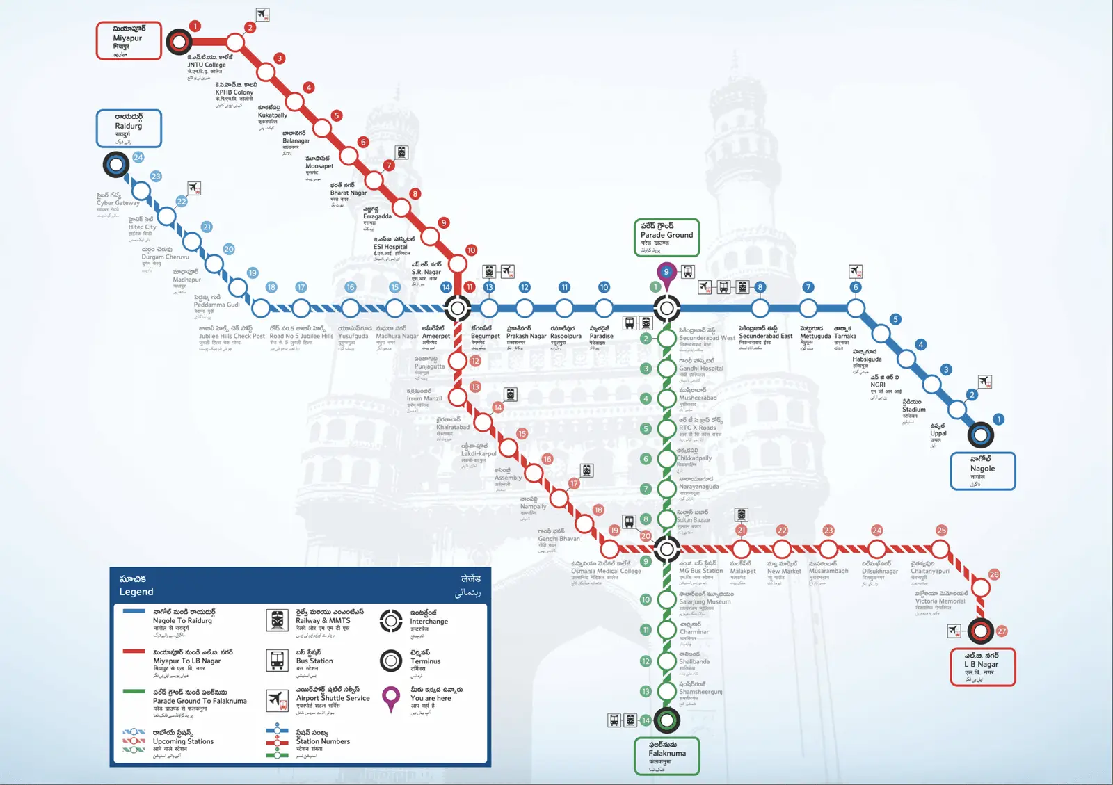
Click or tap the map to enlarge it.
Key Takeaways
- Hyderabad Metro is a rapid transit system serving the city of Hyderabad, India.
- The metro network consists of three lines, with a total length of approximately 69 kilometers.
- It provides an efficient and convenient mode of transportation for the residents and visitors of Hyderabad.
- The metro map showcases the various stations and routes in a clear and organized manner.
- Hyderabad Metro has significantly contributed to reducing traffic congestion and improving public transportation in the city.
History of Hyderabad Metro
The construction of Hyderabad Metro began in 2012, and the first stretch of the metro line was inaugurated on November
28, 2017. It was a remarkable milestone for the city, as Hyderabad became the second city in South India to have a
metro system after Chennai.
The project was undertaken by the Hyderabad Metro Rail Limited (HMRL) in collaboration with Larsen & Toubro (L&T), a
leading Indian multinational conglomerate. The aim was to provide a modern, efficient, and eco-friendly mode of
transportation to cater to the growing needs of the city’s population.
Unique Insights
Hyderabad Metro is not simply a means of transportation, but also an architectural marvel. The stations are designed
with a blend of modern and traditional aesthetics, reflecting the rich culture and heritage of Hyderabad. The
platforms and concourses are spacious and well-lit, providing a comfortable experience for commuters.
Another interesting aspect is the integration of various modes of transportation. The metro stations are seamlessly
connected to bus depots, parking facilities, and other modes of public transport, making it easy for commuters to
switch between different modes for their journeys.
Hyderabad Metro: Relevant Facts
| Year | Event |
|---|---|
| 2012 | Construction of Hyderabad Metro commenced. |
| 2017 | First stretch of the metro line inaugurated. |
| 2020 | COVID-19 pandemic led to a temporary suspension of services. |
| 2022 | Projected completion of all three metro lines. |
Frequently Asked Questions (FAQ)
-
1. How many lines are there in the Hyderabad Metro?
The Hyderabad Metro network consists of three lines: Red Line, Blue Line, and Green Line.
-
2. Are there any plans for future expansions?
Yes, there are plans for future expansions to extend the metro network further into the outskirts of the city.
-
3. Can I use the same ticket for multiple lines?
Yes, the metro ticket allows for interchange between different lines for a smooth journey.
-
4. Is Hyderabad Metro accessible for persons with disabilities?
Absolutely! Hyderabad Metro stations are equipped with elevators and ramps for easy accessibility.
-
5. What is the frequency of metro trains?
The frequency of metro trains varies throughout the day, with higher frequency during peak hours.
-
6. Is there a dedicated ladies’ compartment in the metro?
Yes, there are dedicated compartments for ladies to ensure a safe and comfortable journey.
-
7. How can I recharge my metro card?
Metro cards can be recharged at metro stations using ticket vending machines or through online portals.