Cairo Metro Map
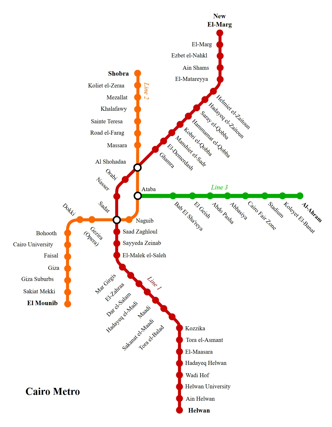
Click or tap the map to enlarge it.
Cairo Metro Map – An Expert Cartographer’s Guide
Key Takeaways
- The Cairo Metro is a rapid transit system serving Cairo, the capital city of Egypt.
- It is one of the most important modes of transportation in the city, with millions of passengers using it every day.
- The metro network provides convenient access to major attractions, government institutions, universities, and residential areas.
History of Cairo Metro
The Cairo Metro has a rich history that dates back to its opening in 1987. The idea of constructing a metro system in Cairo was first proposed in the 1970s as a solution to the city’s growing traffic congestion and the need for a reliable public transportation system.
Construction of the first phase began in 1982, supported by funding and technical assistance from the French government. The first line, Line 1, was opened to the public on September 27, 1987, connecting the districts of Helwan and El Marg.
Over the years, the metro network has expanded with the addition of new lines and extensions. The current system consists of three operational lines: Line 1 (El Marg-Helwan), Line 2 (Shubra El Kheima-Maspero), and Line 3 (Cairo International Airport-Cairo University).
Unique Insights
The Cairo Metro stands out for several reasons. Firstly, it is the first metro system built in Africa and the Arab world, making it a symbol of modernization and progress. It has played a crucial role in transforming the city’s transportation infrastructure and easing congestion on the roads.
Another unique aspect of the Cairo Metro is its architecture. Many of the metro stations are adorned with stunning artwork, including murals, sculptures, and mosaics. This artistic touch adds to the overall experience of traveling through the metro and showcases Egypt’s cultural heritage.
The metro system also promotes accessibility and inclusivity. It has designated spaces for individuals with disabilities, making it easier for them to navigate the stations and trains. Additionally, the metro offers separate cars for women to ensure their safety and comfort during the journey.
Table of Relevant Facts
| Year | Event |
|---|---|
| 1987 | Line 1 (Helwan-El Marg) opens to the public. |
| 1996 | Line 2 (Shubra El Kheima-Maspero) becomes operational. |
| 2012 | Line 3 (Cairo International Airport-Cairo University) is inaugurated. |
| 2023 | Expected completion of Line 4 (El-Malek El-Saleh-Metro 3rd Line) and Line 5 (New Administrative Capital-El-Malek El-Saleh). |
FAQ
1. How many lines does the Cairo Metro have?
The Cairo Metro currently has three operational lines: Line 1, Line 2, and Line 3.
2. How many stations are there in the Cairo Metro?
The Cairo Metro has a total of 61 stations spread across its three lines.
3. Can women travel safely on the Cairo Metro?
Absolutely! The Cairo Metro offers separate cars exclusively for women to ensure their safety and comfort during the journey.
4. Are there any accessibility features for individuals with disabilities?
Yes, the Cairo Metro provides designated spaces and facilities for individuals with disabilities, promoting inclusivity and easy navigation within the stations and trains.
5. How many passengers use the Cairo Metro daily?
The Cairo Metro caters to millions of passengers every day, making it an essential mode of transportation in the city.
6. What is the future expansion plan for the Cairo Metro?
The future expansion of the Cairo Metro includes the completion of Line 4 (El-Malek El-Saleh-Metro 3rd Line) and Line 5 (New Administrative Capital-El-Malek El-Saleh) by 2023.
7. Can tourists use the Cairo Metro to explore the city?
Absolutely! Tourists can conveniently use the Cairo Metro to access major attractions, government institutions, universities, and residential areas, making it an ideal mode of transportation for exploring the city.