Ice Age Europe Map
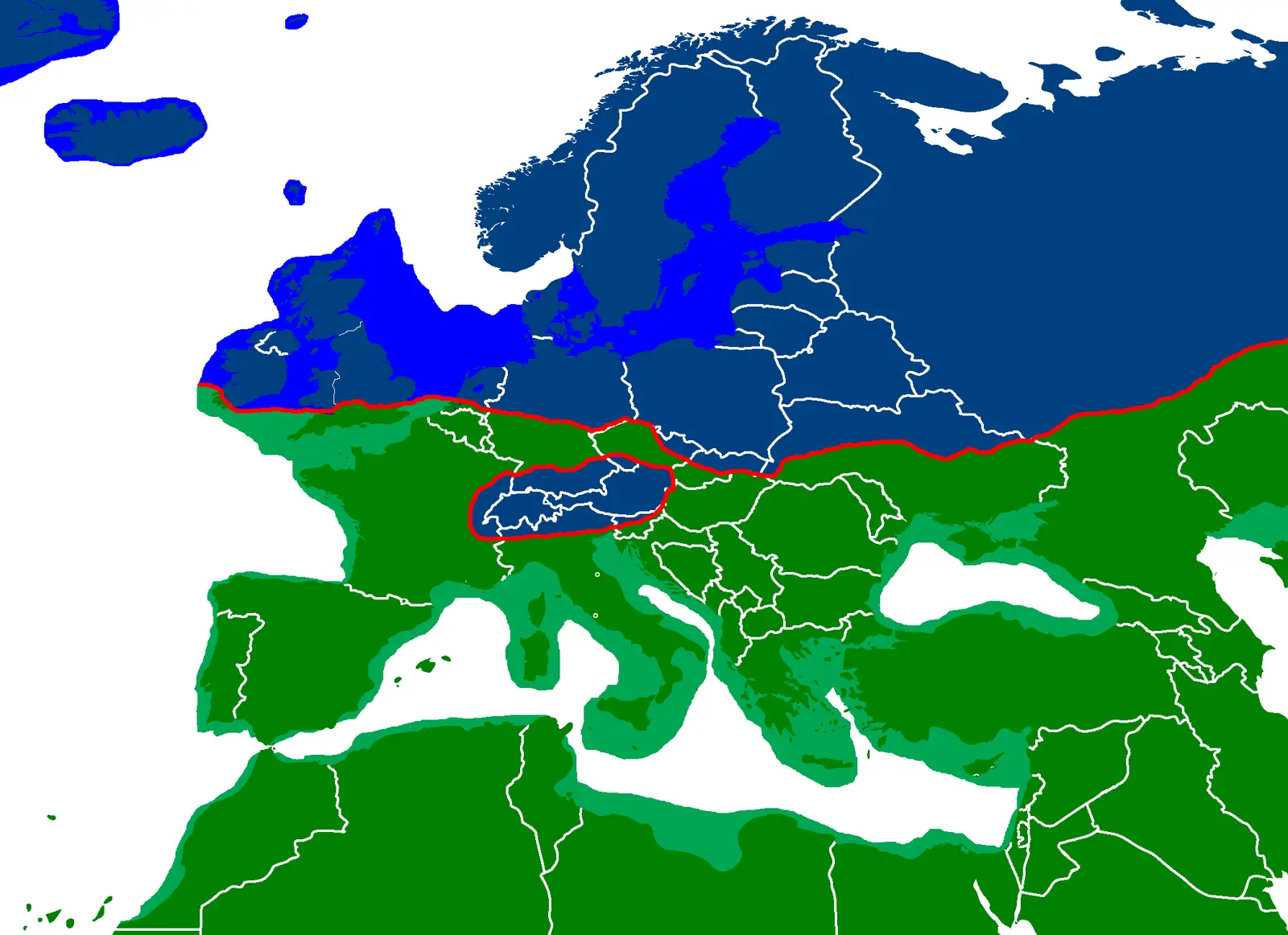
Click or tap the map to enlarge it.
Key Takeaways:
- The Ice Age Europe Map depicts the geographical changes that occurred during the last glacial period.
- It showcases the extensive ice sheets, glaciers, and landmasses that existed during this time.
- This map provides valuable insights into the past climate and the distribution of flora and fauna.
- Studying Ice Age Europe helps us understand the impacts of climate change on landscapes and species.
- The map allows researchers and enthusiasts to visualize the drastic transformations that have shaped our planet.
History:
The Ice Age Europe Map takes us back to a time when much of Europe was covered by ice sheets and glaciers, transforming the landscape dramatically. The last glacial period, commonly referred to as the Ice Age, occurred between approximately 110,000 and 12,000 years ago.
During this period, massive ice sheets formed, advancing and retreating multiple times due to shifts in climate. The weight of the ice in some areas caused the land to depress, while in other regions, glaciers carved out deep valleys and fjords.
The Ice Age Europe Map showcases the extent of these ice sheets and the landmasses that were exposed during glaciations. From Scandinavia to the British Isles, from the Alps to the Iberian Peninsula, the presence of ice and characteristic landforms greatly impacted the geography and ecology of the region.
Unique Insights:
The Ice Age Europe Map offers unique insights into the past climate and the distribution of flora and fauna. It provides a visual representation of the challenges faced by humans and other species during this time.
By studying the map, researchers have discovered that the ice sheets acted as barriers, limiting the movement of populations and influencing the colonization of certain areas. It also helps us understand the adaptations of species to extremely cold environments and the subsequent changes in biodiversity as the climate shifted.
Furthermore, the map reveals the existence of land bridges, such as the Doggerland, which connected the British Isles to mainland Europe. These land bridges played a crucial role in facilitating the migration of both animals and early humans.
Facts about Ice Age Europe:
| Period | Main Features |
|---|---|
| Pleistocene Epoch (2.6 million – 11,700 years ago) | Multiple glacial and interglacial cycles; extensive ice sheets and glaciers covering much of Europe; land bridges connecting various regions; diverse megafauna. |
| Last Glacial Period (110,000 – 12,000 years ago) | Peak glaciation around 21,000 years ago; ice sheets extended across Scandinavia, the British Isles, the Alps, and parts of eastern Europe; presence of glacial lakes and rivers. |
Frequently Asked Questions (FAQ):
-
What caused the ice sheets to form during the last glacial period?
The formation of ice sheets was primarily driven by variations in the Earth’s orbit and axial tilt, affecting the amount and distribution of solar radiation reaching the planet.
-
How did the presence of ice sheets affect human populations?
The ice sheets created barriers that limited human movement and influenced settlement patterns. Some areas were only accessible via land bridges, fostering interaction and migration.
-
What kind of animals lived in Ice Age Europe?
Ice Age Europe was home to various megafauna, including woolly mammoths, woolly rhinoceroses, cave bears, and cave lions.
-
What are some significant landforms created during the Ice Age?
Landforms such as glacial valleys, fjords, and moraines were formed by the movement of glaciers. U-shaped valleys and drumlins are common features in glaciated regions.
-
Did humans inhabit Ice Age Europe?
Yes, early humans, such as Neanderthals and later Homo sapiens, inhabited Ice Age Europe. They adapted to the harsh conditions and developed unique cultural practices.
-
How did the melting of the ice sheets affect sea levels?
As the ice sheets melted, significant amounts of water were released into the oceans. This led to a rise in sea levels, which submerged areas that were once land.
-
What can studying Ice Age Europe tell us about climate change?
Studying Ice Age Europe provides insights into the long-term effects of climate change on landscapes, ecosystems, and species. It helps us understand the dynamic nature of our planet’s climate system.