Interstate 65 Map
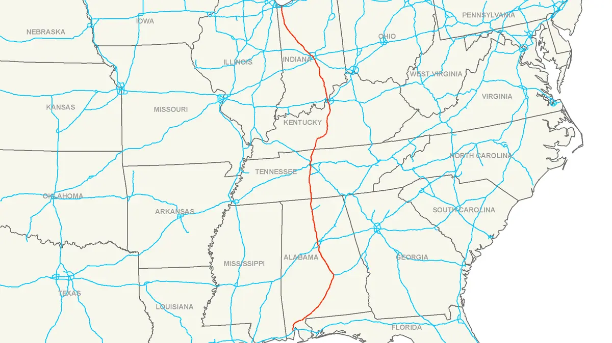
Click or tap the map to enlarge it.
This highway map traces the route of Interstate 65 across the central United States, along with many of the other highways that cross it. I-65 runs for about 887 miles (1,427 km) from Mobile, Alabama, on the Gulf Coast to Gary, Indiana, on the southern shore of Lake Michigan.
On the map the interstate appears as a long north-south spine through four states: Alabama, Tennessee, Kentucky and Indiana.
Cities and crossroads on I-65
Starting at Mobile, the road runs north to Montgomery and Birmingham, then crosses into Tennessee and continues to Nashville. In Kentucky it passes Bowling Green and Louisville, crosses the Ohio River, and climbs through Indiana to Indianapolis before ending near Chicago at Gary.
Major junctions include I-10 at Mobile, I-85 at Montgomery, I-20 and I-59 at Birmingham, I-40 and I-24 at Nashville, I-64 at Louisville and I-70 at Indianapolis. The freight and passenger traffic that uses these junctions links the Gulf ports with the Midwest.
How interstate numbers work
The Interstate Highway System was authorised by the Federal-Aid Highway Act of 1956. Routes with odd numbers run north-south, and numbers rise from west to east, so I-65 lies between I-55 and I-75. Even-numbered routes run east-west. Most of I-65 was built in segments from the late 1950s onward.
Tolling is rare on the interstate, but the John F. Kennedy Memorial Bridge, which carries I-65 over the Ohio River at Louisville, has had electronic tolls since 2016.
Key facts
| Fact | Detail |
|---|---|
| Southern end | Mobile, Alabama (junction with I-10) |
| Northern end | Gary, Indiana (junction with I-90) |
| States crossed | Alabama, Tennessee, Kentucky, Indiana |
| Length | About 887 miles (1,427 km) |
| Largest cities on route | Birmingham, Nashville, Louisville, Indianapolis |
Questions about this map
Why is it numbered 65?
Odd interstate numbers run north-south and increase from west to east, so 65 sits between 55 and 75.
Which states does I-65 pass through?
Alabama, Tennessee, Kentucky and Indiana.
Is I-65 a toll road?
No, but the Louisville bridges across the Ohio River have charged electronic tolls since 2016.