Ireland Road Map
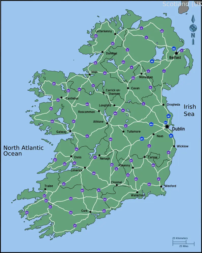
Click or tap the map to enlarge it.
Ireland Road Map: Explore the Beauty of the Emerald Isle
Key Takeaways
- Discover the scenic beauty and cultural richness of Ireland through its roadways.
- An Ireland road map is an essential tool for exploring the country’s diverse landscapes and historic sites.
- Plan your journey with confidence using detailed maps, highlighted routes, and essential tourist information.
- Immerse yourself in Ireland’s charm as you explore its breathtaking coastal drives, vibrant cities, and quaint villages.
- Experience the warmth of the Irish hospitality as you discover hidden gems along the way.
History of Ireland Road Maps
Ireland road maps have a long history that dates back to the early 19th century. The first detailed road maps of
Ireland were produced by cartographers who aimed to provide travelers with accurate and reliable information.
These early maps were often hand-drawn and lacked the level of detail we see in modern-day maps.
As the transportation network in Ireland improved with the development of railways and roads, the demand for more
comprehensive and accessible road maps grew. In the late 19th century, printing technologies advanced, allowing for
the mass production of maps.
With the advent of automobiles and the rise of tourism in the 20th century, road maps became even more crucial for
travelers exploring Ireland. They offered valuable information on roads, landmarks, distances, and attractions,
making it easier for people to navigate and explore the beautiful country.
Unique Insights
Exploring Ireland through its roadways offers unique insights into the country’s natural beauty, culture, and
history. Here are a few insights to consider:
- Ireland’s coastal drives, such as the Wild Atlantic Way and the Causeway Coastal Route, offer breathtaking
views of rugged cliffs, pristine beaches, and charming coastal towns. - The countryside is dotted with ancient castles, ruins, and historic sites, providing a glimpse into Ireland’s
rich heritage. - Driving through the Wicklow Mountains reveals stunning landscapes, picturesque valleys, and serene lakes.
- Ireland’s cities, including Dublin, Belfast, and Galway, offer a vibrant mix of history, culture, and
entertainment. Each city has its own unique charm and attractions. - Exploring Ireland’s small villages and towns allows you to experience the warm hospitality and friendly nature
of the Irish people. Don’t miss the opportunity to chat with locals and discover hidden gems.
Table: Relevant Facts
| Year | Event |
|---|---|
| 1700s | Early road maps of Ireland are hand-drawn but lack detail. |
| Late 19th century | Printing technologies advance, allowing for mass production of road maps. |
| 20th century | Automobiles and tourism contribute to the increased importance of road maps. |
Frequently Asked Questions (FAQ)
1. Why should I use an Ireland road map?
An Ireland road map provides essential information for planning your journey, guiding you through the country’s
roadways, and highlighting key attractions and landmarks along the way. It gives you a sense of direction and
helps you discover hidden gems.
2. Are Ireland road maps available in multiple languages?
Yes, you can find Ireland road maps in various languages, including English, Irish (Gaeilge), German, French,
Spanish, and more. Choose the language option that suits your needs.
3. Can I rely solely on GPS navigation instead of using a road map?
While GPS navigation can be convenient, it is always wise to carry a road map as a backup. GPS signals can be
weak or unreliable in some remote areas of Ireland. Having a physical map ensures you won’t get lost.
4. Where can I purchase an Ireland road map?
You can purchase Ireland road maps from local bookstores, tourist information centers, online retailers, or
convenience stores. They are widely available throughout the country.
5. Can I use a digital road map instead of a physical one?
Yes, digital road maps are available and can be used on smartphones or GPS devices. However, keep in mind that
not all areas will have reliable internet or network coverage. It’s a good idea to have a physical map as a
backup.
6. Are there specific maps for cycling routes in Ireland?
Yes, there are specialized maps available specifically for cycling routes in Ireland. These maps highlight
designated cycling paths and offer information suited for cyclists.
7. Can I find detailed maps of specific regions within Ireland?
Absolutely! There are detailed maps available for regions like Connemara, the Ring of Kerry, Giant’s Causeway,
and more. These maps provide in-depth information and highlight points of interest for each region.