Map of Ireland
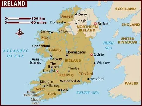
Click or tap the map to enlarge it.
Map of Ireland – Key Takeaways, History, Unique Insights, Facts, FAQ
Key Takeaways
- Ireland is an island located in the North Atlantic Ocean.
- The map of Ireland showcases the country’s counties, cities, and natural landmarks.
- Ireland is known for its lush green landscapes, vibrant culture, and rich history.
- The map serves as a useful tool for navigating and exploring the country’s diverse regions.
- From historic sites to stunning coastal scenery, Ireland offers a wide range of attractions for travelers.
History
The history of Ireland is a complex and fascinating tale that spans thousands of years. The map of Ireland provides a visual representation of the country’s historical divisions and regions.
From ancient Celtic tribes to Viking invasions and English colonization, Ireland has been shaped by a series of significant events. The map showcases the division of the island into 32 counties, each with its own unique history and cultural identity.
One notable event in Ireland’s history is the Great Famine that occurred between 1845 and 1852. The map may help visualize the impact of this devastating period, where millions of people suffered from starvation and emigration.
Another significant development in Irish history is the struggle for independence from British rule. The map can highlight key locations associated with this period, such as the Easter Rising in 1916 and the signing of the Anglo-Irish Treaty in 1921.
Unique Insights
The map of Ireland offers several unique insights into the country’s geography and culture:
- Ireland is divided into four provinces: Leinster, Munster, Connacht, and Ulster.
- The map showcases the vibrant cities of Dublin, Belfast, Cork, Galway, and Limerick, each with its distinct character and attractions.
- The coastline of Ireland is known for its breathtaking cliffs, including the famous Cliffs of Moher.
- The map highlights the presence of several ancient castles and ruins, such as Blarney Castle and Rock of Cashel, providing a glimpse into Ireland’s medieval past.
- The map also displays the island’s mountains and lakes, offering opportunities for outdoor enthusiasts to engage in activities like hiking and fishing.
Relevant Facts
| Year | Event |
|---|---|
| 1169 | The Norman invasion of Ireland begins. |
| 1801 | Act of Union merges the Kingdom of Ireland and the Kingdom of Great Britain. |
| 1916 | The Easter Rising takes place in Dublin. |
| 1921 | The Anglo-Irish Treaty is signed, leading to the establishment of the Irish Free State. |
| 1998 | The Good Friday Agreement is signed, aiming to strengthen peace and stability in Northern Ireland. |
FAQ
-
1. What are the major cities on the map of Ireland?
The major cities on the map of Ireland include Dublin, Belfast, Cork, Galway, and Limerick.
-
2. What are the key landmarks in Ireland?
Ireland is known for its stunning landmarks, such as the Cliffs of Moher, Blarney Castle, Giant’s Causeway, and Ring of Kerry.
-
3. How many counties are there in Ireland?
Ireland is divided into 32 counties.
-
4. What is the history of Irish independence?
Irish independence was a result of a long struggle against British rule, culminating in the establishment of the Irish Free State in 1921.
-
5. What is the significance of the Easter Rising?
The Easter Rising in 1916 was a rebellion against British rule, marking a significant step towards Irish independence.
-
6. Are there any famous Irish writers or poets?
Ireland is known for its rich literary history, with famous writers and poets like Oscar Wilde, James Joyce, and W.B. Yeats.
-
7. What are some popular Irish folk traditions?
Ireland has a strong tradition of storytelling, music, and dance. Traditional Irish folk music and Gaelic sports like hurling and Gaelic football are also popular.