Isle of Skye Uk Relief Location Map Labels
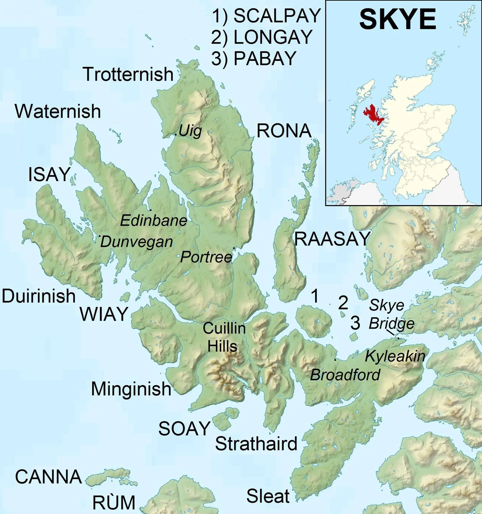
Click or tap the map to enlarge it.
Key Takeaways
- The Isle of Skye in the United Kingdom is a beautiful and picturesque location.
- The relief location map provides valuable information on the landscape and topography of the island.
- Understanding the geography of the Isle of Skye is essential for tourists and explorers.
- The map labels help identify key landmarks, mountain ranges, and geographical features.
- Exploring the Isle of Skye presents an opportunity to witness breathtaking natural beauty.
History
The Isle of Skye, located in the northwest of Scotland, has a rich history that dates back thousands of years. Its name is derived from the Old Norse language, meaning “Cloud Island,” due to its often misty and atmospheric conditions. The island has been inhabited since the Mesolithic period, with evidence of human presence dating back to 6,000 BC. Throughout its history, Skye has been a significant center of culture and trade, influenced by the Vikings, Celts, and Scots.
The Isle of Skye played a prominent role in the Jacobite risings of the 17th and 18th centuries. It was a strategic location in the battle between the Jacobites, who sought to restore the exiled King James VII of Scotland and II of England to the throne, and the British government. The island witnessed numerous conflicts and skirmishes, leaving behind a legacy of historical significance.
Unique Insights
The relief location map of the Isle of Skye provides insights into the island’s diverse landscapes and geographical features. It showcases the mighty Cuillin mountain range, known for its challenging peaks, rugged terrain, and exceptional beauty. The map also highlights the unique natural landmarks, including the mystical Fairy Pools, Old Man of Storr, and the stunning Quiraing. These natural wonders attract visitors from all over the world, offering opportunities for hiking, photography, and immersing in the untamed wilderness.
The map labels serve as a valuable guide for explorers and adventurers. They assist in identifying the different mountain ranges, peaks, lochs, and rivers that define Skye’s topography. Understanding the geographical layout of the island helps visitors plan their journeys, discover hidden gems, and appreciate the diverse ecosystems that exist within this small but captivating piece of land.
Table of Relevant Facts
| Year | Event |
|---|---|
| 6,000 BC | Evidence of human presence in Skye during the Mesolithic period |
| 17th and 18th centuries | Isle of Skye plays a significant role in the Jacobite risings |
Frequently Asked Questions
-
What is the Isle of Skye known for?
The Isle of Skye is known for its stunning natural landscapes, including the Cuillin mountain range, Fairy Pools, and the Quiraing. It is also famous for its rich history and cultural heritage.
-
How can I explore the Isle of Skye?
Exploring the Isle of Skye can be done by car, bike, or on foot. There are numerous hiking trails, scenic drives, and guided tours available to help you navigate the island’s wonders.
-
Are there any accommodations on the Isle of Skye?
Yes, the Isle of Skye offers a range of accommodations, including hotels, bed and breakfasts, self-catering cottages, and camping sites. It is advisable to book in advance, especially during peak tourist seasons.
-
What is the best time to visit the Isle of Skye?
The best time to visit the Isle of Skye is during the spring and summer months (May to September). The weather is generally milder, and the long daylight hours allow for more exploration and outdoor activities.
-
Are there any famous landmarks on the Isle of Skye?
Yes, the Isle of Skye is home to several iconic landmarks, such as the Fairy Pools, Old Man of Storr, Dunvegan Castle, and the Talisker Distillery.
-
Can I hike in the Cuillin mountain range?
Hiking in the Cuillin mountains requires experience and proper equipment. The range offers both challenging climbs for experienced mountaineers and less strenuous hikes for beginners.
-
How do I get to the Isle of Skye?
The Isle of Skye can be reached by road via the Skye Bridge or by ferry from Mallaig or Glenelg. The nearest airports are Inverness and Glasgow, with regular bus and train connections to the island.