Map of Lord’s Cricket Ground with Stands
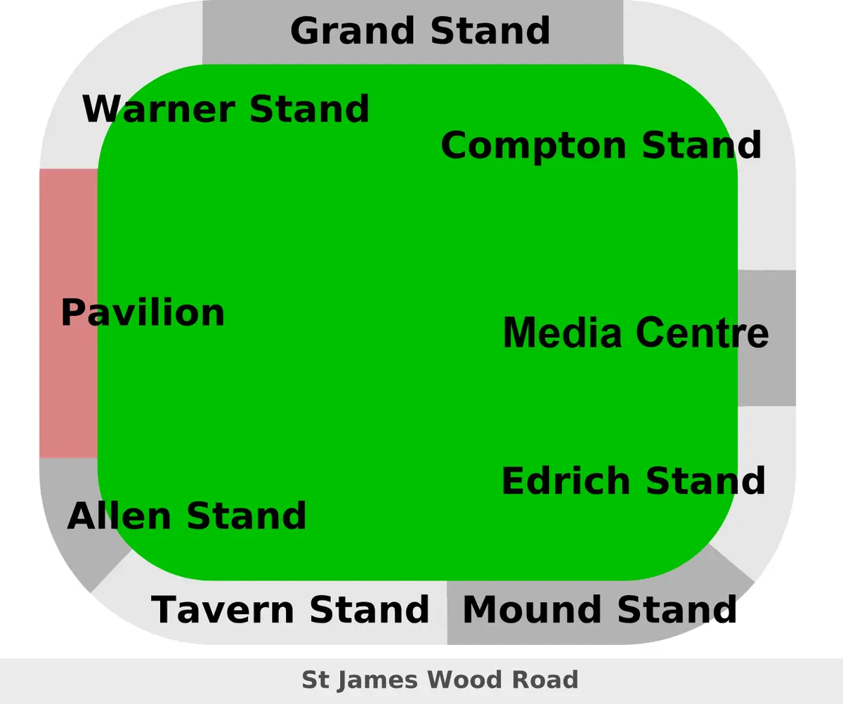
Click or tap the map to enlarge it.
This schematic plan of Lord's Cricket Ground in north London names its stands: the Pavilion, the Warner, Compton, Edrich, Allen, Tavern and Mound Stands and the Media Centre. Lord's is the home of the Marylebone Cricket Club (MCC) and of Middlesex County Cricket Club.
The ground has hosted Test cricket since 1884 and stages a Test match every English summer.
A ground with a slope
Lord's is known for its slope: the playing surface falls by roughly 2.5 metres from the north-west corner to the south-east. The Pavilion, finished in 1890, is the heart of the ground and houses the MCC's famous Long Room. Modern stands such as the Compton and Edrich Stands (1991) sit alongside the media centre, a 1999 design of aluminium and glass that was built to look unlike the traditional stands.
The ground's current site is the third to be called Lord's. It opened in 1814 after the two earlier grounds, one near Dorset Square, were abandoned.
Records and finals
Lord's has hosted five men's Cricket World Cup finals, in 1975, 1979, 1983, 1999 and 2019, the last of them the final between England and New Zealand, which ended in a tie and was decided by a super over. Its capacity is a little over 31,000.
Visiting Lord's
Lord's lies in St John's Wood and is named after Thomas Lord, who founded the first ground in 1787. The Grace Gates, built in 1923, honour the cricketer W. G. Grace. The MCC Museum at the ground is one of the oldest sporting museums in the world and houses the Ashes urn, the small terracotta trophy that symbolises the Test series between England and Australia. Ground tours run on days without matches.
Key facts
| Fact | Detail |
|---|---|
| Home clubs | MCC and Middlesex |
| Current ground opened | 1814 |
| First Test | 1884 |
| Capacity | About 31,000 |
| Playing surface slope | About 2.5 m |
Questions about this map
What is the Long Room?
A famous room in the Pavilion where members watch the cricket.
What is the media centre?
A modern press box and broadcast building at the Nursery end, opened in 1999.
Is the plan to scale?
No, it is schematic, intended to show the names and positions of stands.