Map of Nepal Political and Administrative
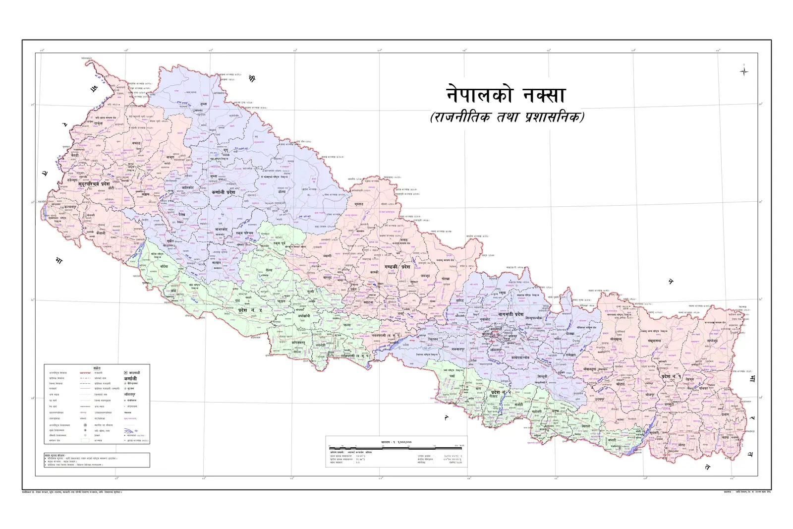
Click or tap the map to enlarge it.
Map Of Nepal Political And Administrative
Key Takeaways
Below are the key takeaways from the map of Nepal, highlighting its political and administrative divisions:
- Nepal is divided into seven provinces, each with its own capital.
- The country has a total of 77 districts, which are further divided into municipalities and rural municipalities.
- Kathmandu is the capital city of Nepal and is located in Province 3.
- The map provides an overview of the political structure of Nepal and helps in understanding its administrative divisions.
History
Nepal is a country located in South Asia, surrounded by India from three sides and China from one side. The political and administrative divisions of Nepal have evolved over time. Prior to the current federal structure, Nepal had a centralized governance system where all the decision-making powers were concentrated in the capital city.
However, with the adoption of a new constitution in 2015, Nepal transitioned into a federal democratic republic, dividing the country into seven provinces. The objective was to ensure the effective distribution of power and resources among the different regions of the country.
Unique Insights
While studying the map of Nepal, the following unique insights can be observed:
- Province 3, which includes Kathmandu, the capital city, is the smallest province in terms of area but has the highest population density.
- Province 2, located in the southern plains, is the most populous province and has significant cultural and ethnic diversity.
- Province 7, situated in the far-western region, is the largest province in terms of area.
- The hilly regions of Nepal, including Province 3, 4, and 5, are known for their scenic beauty and are major tourist destinations.
- Province 6, located in the far-western part of Nepal, shares its border with Uttarakhand state of India.
Table of Relevant Facts
| Province | Capital | No. of Districts |
|---|---|---|
| Province 1 | Biratnagar | 14 |
| Province 2 | Janakpur | 8 |
| Province 3 | Kathmandu | 13 |
| Province 4 | Pokhara | 11 |
| Province 5 | Nepalgunj | 12 |
| Province 6 | Dipayal Silgadhi | 10 |
| Province 7 | Dhangadhi | 9 |
FAQs (Frequently Asked Questions)
1. What are the administrative divisions of Nepal?
Nepal is divided into seven provinces, which are further divided into 77 districts, municipalities, and rural municipalities.
2. How many municipalities and rural municipalities are there in Nepal?
Nepal has a total of 276 municipalities and 460 rural municipalities.
3. Which province is Kathmandu, the capital city, located in?
Kathmandu is located in Province 3 of Nepal.
4. Which province has the highest population density?
Province 3, which includes Kathmandu, has the highest population density.
5. Which province is the largest in terms of area?
Province 7, situated in the far-western region, is the largest province in terms of area.
6. How many districts are there in Province 4?
Province 4 consists of 11 districts.
7. What was the reason behind the division of Nepal into provinces?
The division of Nepal into provinces was carried out to ensure the effective distribution of power and resources among the different regions of the country.
For more information, you can refer to the official website of Nepal.
LSI Keywords
- Map of Nepal
- Nepal political map
- Nepal administrative divisions
- Provinces in Nepal
- Nepal districts
- Capital city of Nepal
- Kathmandu province
- Nepal population density
- Geographical regions of Nepal
- Nepal federal structure
- Nepal tourism
- Cultural diversity in Nepal
- Border of Nepal
- Nepal municipalities
- Rural municipalities in Nepal