Mapa Esquemtico del la Red de Metro de Madrid
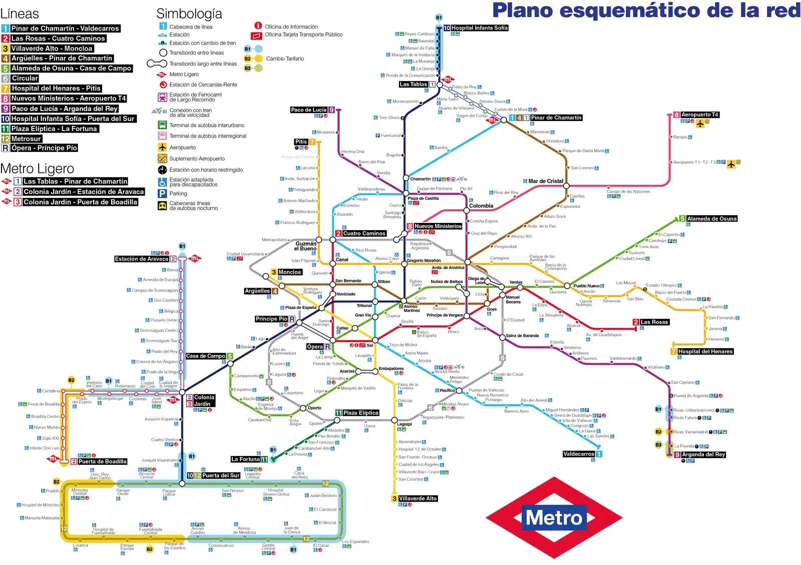
Click or tap the map to enlarge it.
Mapa Esquemático Del La Red De Metro De Madrid
Key Takeaways:
- The metro network in Madrid, known as the “Red de Metro de Madrid”, is a comprehensive and efficient transportation system.
- The map of the metro network provides a visual representation of the lines, stations, and connections in Madrid.
- Understanding how to read and navigate the metro map is essential for both locals and tourists traveling in Madrid.
- The development and expansion of the metro system have contributed significantly to the city’s growth and accessibility.
History of the Red de Metro de Madrid:
The Red de Metro de Madrid, or the Madrid Metro, is one of the oldest and largest metro networks in Europe. Its construction began in 1919, and the first line was opened to the public on October 17, 1919. Over the years, the network has expanded to cover a significant portion of the city and its suburbs.
The Madrid Metro has played a crucial role in the development and modernization of the city. It has become an essential mode of transportation for both daily commuters and tourists. The expansion of the metro lines has also contributed to the accessibility of various neighborhoods and suburbs, making it easier for people to travel efficiently.
Unique Insights:
1. The Madrid Metro is the second-largest metro system in Europe, with a total length of over 294 kilometers and approximately 302 stations. It covers a vast area, connecting different parts of the city.
2. The metro system in Madrid is known for its efficiency and reliability. The trains are frequent and well-maintained, ensuring minimal delays and disruptions for commuters.
3. The metro network is color-coded, with each line represented by a different color. This visual representation makes it easy for passengers to identify their desired line and navigate the system.
4. The metro stations in Madrid showcase a blend of modern architecture and historical elements. Some stations even exhibit artwork and unique designs, creating a pleasant and memorable commuting experience.
5. The metro network in Madrid offers convenient connections to major transportation hubs such as airports, bus stations, and train stations. This makes it an ideal choice for travelers arriving or departing from the city.
Relevant Facts:
| Year | Fact |
|---|---|
| 1919 | The first line of the Madrid Metro was opened to the public. |
| 1924 | The second line, Line 2, was inaugurated. |
| 1932 | The third line, Line 3, was opened. |
| 1944 | Line 4 was inaugurated. |
| 1979 | The metro system expanded with the opening of Line 5. |
| 1995 | Line 10, also known as the Circle Line, became operational. |
| 2015 | The latest line, Line 12 or MetroSur, was added to the network. |
Frequently Asked Questions (FAQ):
1. How many lines are there in the Red de Metro de Madrid?
There are currently 12 lines in the Madrid Metro network.
2. How many stations are there in the Madrid Metro?
The Madrid Metro has approximately 302 stations.
3. Is the Madrid Metro open 24 hours?
No, the Madrid Metro operates from approximately 6:00 AM to 1:30 AM.
4. How can I purchase a metro ticket in Madrid?
You can purchase a metro ticket at the ticket vending machines available at all metro stations.
5. Are there any discounted fares for frequent travelers?
Yes, the Madrid Metro offers various discounted fares and travel cards for frequent travelers.
6. Can I take luggage on the Madrid Metro?
Yes, you can take luggage on the Madrid Metro as long as it does not cause inconvenience to other passengers.
7. Are there any accessibility features for disabled passengers?
Yes, the Madrid Metro has made efforts to ensure accessibility for disabled passengers, including elevators and tactile paving.