The Peloponnese in the Middle Ages: Map
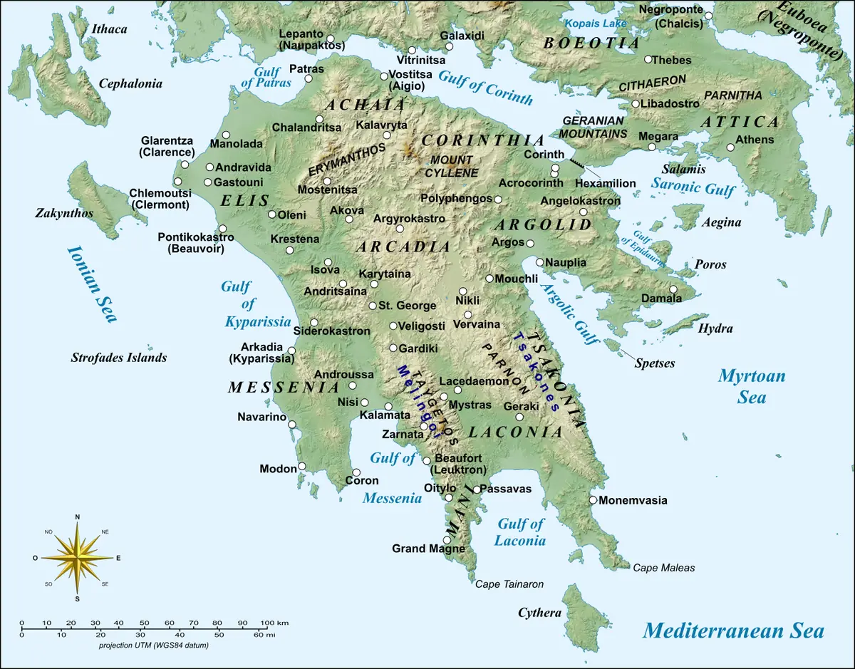
Click or tap the map to enlarge it.
This map of the Peloponnese, the southern peninsula of mainland Greece, labels the ancient regions of Achaea, Elis, Arcadia, Messenia, Laconia, Argolis and Corinthia on a relief background. Many of these names were still used in the Middle Ages.
The Peloponnese is connected to the rest of Greece only by the narrow Isthmus of Corinth, which has been cut by a canal since 1893.
Byzantines, Franks and Venetians
In the early Middle Ages Slavic groups settled parts of the peninsula, and the Byzantine Empire gradually reasserted control. After the Fourth Crusade in 1204, French knights founded the Principality of Achaea, with castles such as Chlemoutsi, and the Venetians held coastal ports like Methoni and Koroni. Byzantium recovered the south-east after the Battle of Pelagonia in 1259, and from 1349 the peninsula was governed as the Despotate of the Morea from the fortified city of Mystras.
The Ottomans conquered the Despotate in 1460. Venice held the region briefly from 1687 to 1715 before the Ottomans returned.
Why the region mattered
The peninsula's long coastline and mountain passes made it a place where Greek, Frankish, Venetian and Ottoman powers met. Mystras, now a UNESCO site, preserves churches and palaces from the late Byzantine revival, and many place names on the map echo the classical regions, such as Messenia and Laconia, reused through the Middle Ages.
Key facts
| Date | Event |
|---|---|
| 1204 | Fourth Crusade; Principality of Achaea founded soon after |
| 1259 | Battle of Pelagonia; Byzantines recover the south-east |
| 1349 | Despotate of the Morea established at Mystras |
| 1460 | Ottoman conquest of the Despotate |
| 1687-1715 | Venetian rule of the Morea |
Questions about this map
What does Morea mean?
It was the medieval name for the Peloponnese.
What is Mystras?
A fortified Byzantine city near Sparta, the capital of the Despotate of the Morea and now a UNESCO site.
How is the Peloponnese connected to the mainland?
By the Isthmus of Corinth, now cut by the Corinth Canal.