Prakasam District Mandals Outline Map
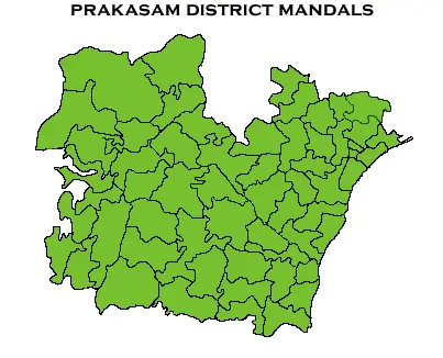
Click or tap the map to enlarge it.
Key Takeaways
- The Prakasam District Mandals Outline Map provides an overview of the administrative regions within Prakasam district in India.
- It helps in understanding the divisions and boundaries of different mandals within the district.
- The map is an invaluable tool for government officials, researchers, and individuals interested in gaining insights about Prakasam district.
- It showcases the geographical features, major cities, towns, and villages within the district.
- Prakasam District Mandals Outline Map can aid in planning various developmental activities and resource allocation within the district.
History
Prakasam district, located in the Indian state of Andhra Pradesh, was formed on February 2, 1970. The district was named after Tanguturi Prakasam, a prominent freedom fighter and the first Chief Minister of Andhra Pradesh. Prakasam district is known for its rich history and cultural heritage.
The district has witnessed significant political, social, and economic changes over the years. It has played a crucial role in India’s struggle for independence and has been an integral part of the state’s growth and development.
Unique Insights
Through the Prakasam District Mandals Outline Map, we gain unique insights into the spatial distribution and organization of the district. Some key insights include:
- The district is divided into a total of 56 mandals, each with its own distinct region and administrative setup.
- Prakasam district is located on the eastern coast of India, bordered by the Bay of Bengal to the east.
- The district encompasses a variety of geographical features, including hills, rivers, and coastal plains.
- Ongole, the district’s headquarters, is a major city in Prakasam district.
- Other significant towns and villages within the district include Chirala, Markapur, Giddalur, Kandukur, and Singarayakonda.
- Prakasam district has a diverse population that is engaged in various occupations, including agriculture, fishing, and small-scale industries.
Table of Relevant Facts
| Year | Event |
|---|---|
| 1970 | Formation of Prakasam district |
| 2004 | Creation of new mandals within the district |
| 2011 | Population of Prakasam district crosses 3 million |
| 2018 | Development of infrastructure projects in the district |
| 2020 | Introduction of new agricultural initiatives |
FAQs
1. How many mandals are there in Prakasam district?
Prakasam district consists of a total of 56 mandals.
2. What is the significance of Ongole in Prakasam district?
Ongole is the headquarters of Prakasam district and serves as an important administrative, commercial, and cultural center.
3. Which are the major towns in Prakasam district?
Some major towns in Prakasam district include Chirala, Markapur, Giddalur, Kandukur, and Singarayakonda.
4. What are the key features of Prakasam District Mandals Outline Map?
The map highlights the boundaries and divisions of different mandals within Prakasam district, along with geographical features, major cities, towns, and villages.
5. How can the map aid in developmental activities?
The Prakasam District Mandals Outline Map provides valuable insights that can help in planning and allocating resources for various developmental activities within the district.
6. Where can I find a high-resolution version of the map?
You can find a high-resolution version of the Prakasam District Mandals Outline Map on the official website of the Prakasam district administration or through relevant government sources.
7. How often are the mandal boundaries updated?
The mandal boundaries within Prakasam district are periodically updated based on administrative requirements and changes in the district’s demographic and geographic factors.