Canada Prairie Provinces Map
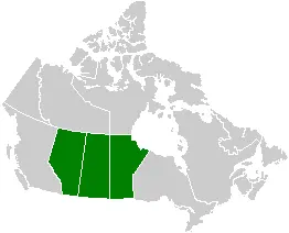
Click or tap the map to enlarge it.
Key Takeaways
- The Canada Prairie Provinces Map showcases the stunning landscape and rich agricultural regions of Canada.
- These provinces, including Alberta, Saskatchewan, and Manitoba, are known for their vast prairies, rolling hills, and fertile farmland.
- The map highlights major cities, rivers, national parks, and other geographical features in the region.
History of Canada Prairie Provinces
The Canada Prairie Provinces, consisting of Alberta, Saskatchewan, and Manitoba, have a fascinating history shaped by diverse cultures and natural resources. The region was originally inhabited by Indigenous peoples, including First Nations and Métis communities, who have a long and rich history in the area.
European settlement in the prairie provinces began in the late 18th century, with fur trade posts established by the Hudson’s Bay Company. The arrival of the Canadian Pacific Railway in the late 19th century played a pivotal role in the development of the region, enabling easier transportation and fostering economic growth.
Over the years, the prairie provinces have become known for their agricultural prosperity. The fertile soil, combined with advancements in technology and farming practices, has made the area a vital contributor to Canada’s agricultural industry.
Unique Insights
1. Diverse Geography
The Canada Prairie Provinces exhibit a diverse range of geographical features. The landscape consists of expansive prairies, rolling hills, vast grasslands, and the iconic aspen parkland.
The region is also home to impressive river systems, including the Saskatchewan River, the Red River, and the South Saskatchewan River, which shape the fertile agricultural lands.
2. Cultural Heritage
The prairie provinces have a rich cultural heritage, influenced by Indigenous populations and diverse immigrant communities. Indigenous traditions, arts, and crafts continue to thrive, and visitors can explore various cultural festivals and events throughout the year.
The region also celebrates its European roots, with many towns and cities retaining their distinct cultural identities. The fusion of different traditions and backgrounds adds vibrancy and diversity to the prairie provinces.
3. Abundant Wildlife
The Canada Prairie Provinces are home to a wide range of wildlife species. The grasslands provide important habitats for various animals, including bison, pronghorn, deer, and numerous bird species.
Visitors can witness the incredible biodiversity by exploring the national parks in the region, such as Banff National Park and Grasslands National Park. These protected areas offer opportunities for hiking, wildlife viewing, and experiencing the natural wonders of the prairie provinces.
Table of Relevant Facts
| Year | Event |
|---|---|
| 1867 | Canada becomes a confederation, including the provinces that would later form the prairie provinces. |
| 1885 | The Canadian Pacific Railway reaches the prairie provinces, opening up transportation and trade opportunities. |
| 1905 | Alberta and Saskatchewan officially become provinces. |
| 1912 | Manitoba becomes the first province in Canada to grant women the right to vote. |
FAQ
1. What are the major cities in the Canada Prairie Provinces?
The major cities in the Canada Prairie Provinces are Calgary and Edmonton in Alberta, Regina and Saskatoon in Saskatchewan, and Winnipeg in Manitoba.
2. Are there any famous national parks in the region?
Yes, the prairie provinces are home to several renowned national parks, including Banff National Park, Jasper National Park, and Grasslands National Park.
3. What is the primary industry in the Canada Prairie Provinces?
Agriculture is the primary industry in the prairie provinces, with the fertile soil supporting a thriving farming sector.
4. Can visitors experience Indigenous culture in the region?
Absolutely! The prairie provinces have a rich Indigenous heritage, and various cultural events, art exhibits, and historical sites allow visitors to engage with and learn about Indigenous cultures.
5. Are there opportunities for outdoor activities in the prairie provinces?
Yes, the region offers a plethora of outdoor activities such as hiking, camping, fishing, and wildlife watching. The national parks and scenic landscapes provide an ideal backdrop for adventure enthusiasts.
6. What is the best time to visit the Canada Prairie Provinces?
The summer months (June to August) offer pleasant weather and vibrant foliage, making it an ideal time for exploration. However, each season in the prairie provinces has its unique charm and attractions.
7. How can I reach the Canada Prairie Provinces?
The prairie provinces are well-connected by air, with major international airports located in Calgary, Edmonton, Regina, Saskatoon, and Winnipeg.