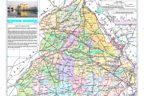
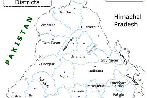
Punjab District Map 2014
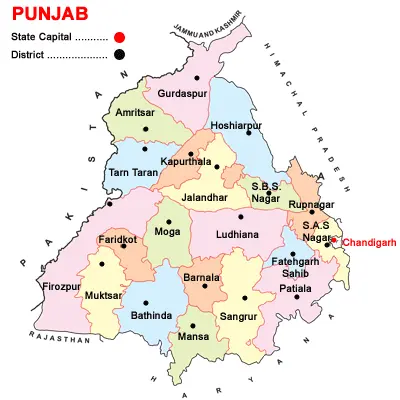
Click or tap the map to enlarge it.
Punjab District Map 2014 – An In-depth Analysis
Key Takeaways
- The Punjab District Map 2014 provides comprehensive information about the districts within the Punjab region.
- This map is an invaluable resource for researchers, historians, travelers, and policymakers.
- It highlights the geographical boundaries, district capitals, and major cities in Punjab during the year 2014.
History
The Punjab District Map 2014 depicts the administrative divisions within the Indian state of Punjab during the specified year. Punjab, often referred to as the ‘Land of Five Rivers,’ has a rich historical and cultural significance. The region has witnessed a plethora of dynasties and empires, shaping its borders over time.
During the British rule in India, Punjab was divided into several administrative districts for efficient governance. The 2014 map represents the districts in existence during that specific year.
Unique Insights
- The Punjab District Map 2014 showcases the vast diversity within the region, from rural agricultural areas to bustling urban centers.
- It highlights the major transportation arteries, such as highways, railways, and airports, that connect different districts in Punjab.
- By analyzing population density within each district, researchers can gain insights into the demographic distribution and density of the region.
- The map allows a comprehensive understanding of the spatial distribution of educational institutions, healthcare facilities, and other public amenities.
- One can explore the distinct cultural heritage, religious sites, and tourist attractions marked on the map, providing valuable insights for planning travel itineraries.
Table of Relevant Facts (2014)
| District | Capital | Population (Approx.) |
|---|---|---|
| Amritsar | Amritsar | 25,29,682 |
| Barnala | Barnala | 6,28,349 |
| Bathinda | Bathinda | 13,25,410 |
| Firozpur | Firozpur | 20,29,074 |
| Gurdaspur | Gurdaspur | 20,64,843 |
| Jalandhar | Jalandhar | 22,78,395 |
Frequently Asked Questions (FAQ)
1. What does the Punjab District Map 2014 represent?
The Punjab District Map 2014 represents the administrative divisions and boundaries of different districts within the state of Punjab during that year.
2. How can researchers and historians benefit from this map?
Researchers and historians can utilize this map to study the demographic distribution, transportation connectivity, and cultural significance of different districts within Punjab during 2014.
3. Can I plan my travel itinerary using this map?
Yes, definitely! This map provides valuable information about tourist attractions, religious sites, and major cities in Punjab, enabling you to plan your travel itinerary effectively.
4. Are there any legends or symbols on the map?
Yes, the map contains legends and symbols that help in deciphering the meaning of different markers and features displayed on the map, such as district boundaries, capital cities, transportation routes, etc.
5. Are there any specific insights related to education and healthcare facilities?
Absolutely! By analyzing the Punjab District Map 2014, researchers can gain insights into the spatial distribution of educational institutions and healthcare facilities within the different districts of Punjab during 2014.
6. Is this map useful for policymakers and government officials?
Yes, this map serves as a valuable resource for policymakers and government officials as it presents a comprehensive overview of the administrative divisions, population distribution, and geographic connectivity within Punjab during 2014.
7. Can I compare the district boundaries of Punjab in 2014 with the present boundaries?
Yes, by referring to the Punjab District Map 2014 and comparing it with the current district boundaries, you can observe any changes or modifications that have occurred over time. This can be helpful for studying the evolution of administrative divisions within the region.