Russia Kaliningrad Location Map
Russia Kaliningrad Location Map
Key Takeaways
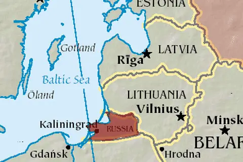
- Kaliningrad is an exclave of Russia, located between Poland and Lithuania.
- This map showcases the precise location of the Kaliningrad Oblast within the larger context of Europe.
- Recognizing the geographical position of Kaliningrad helps understand its unique political and cultural dynamics.
- The region is known for its rich history, stunning architecture, and beautiful natural landscapes.
History of Kaliningrad Oblast
The Kaliningrad Oblast, formerly known as Königsberg, has a fascinating history that dates back centuries. This region was originally inhabited by the Old Prussians, a Baltic tribe, until the Teutonic Knights arrived in the 13th century and established the city of Königsberg.
Königsberg became an important trading hub and a member of the Hanseatic League. It flourished culturally and economically until World War II when it suffered significant damage. After the war, the region fell under Soviet control and was renamed Kaliningrad in 1946.
Due to its strategic location, Kaliningrad became a closed military zone during the Cold War. However, in recent years, the region has undergone development and opened up for tourism and trade.
Unique Insights
- Kaliningrad is the only part of Russia that lies outside of the mainland.
- The region is geographically separated from the rest of Russia by Lithuania and Belarus.
- Kaliningrad serves as an important transportation hub between Russia and Western Europe.
- The city of Kaliningrad, the capital of the oblast, is home to stunning Gothic architecture, such as the Königsberg Cathedral.
- The Curonian Spit, a UNESCO World Heritage site, is a unique natural feature located near Kaliningrad.
Table of Relevant Facts
| Year | Event |
|---|---|
| 1255 | Königsberg is founded by the Teutonic Knights. |
| 1945 | Königsberg is heavily damaged during World War II. |
| 1946 | The region is renamed Kaliningrad. |
| 1991 | The Soviet Union dissolves, and Kaliningrad becomes part of the Russian Federation. |
| 2004 | Kaliningrad gains visa-free travel to neighboring countries as part of Russia’s entry into the World Trade Organization. |
Frequently Asked Questions (FAQ)
-
What is Kaliningrad?
Kaliningrad is an exclave of Russia, geographically separated from the mainland by Lithuania and Belarus.
-
How do you reach Kaliningrad?
Kaliningrad can be reached by air, train, or road. The region has an international airport and is well-connected by rail and highways.
-
What is the main language spoken in Kaliningrad?
Russian is the main language spoken in Kaliningrad. However, due to its historical influences, German and Polish are also spoken by some residents.
-
Is Kaliningrad a popular tourist destination?
Yes, Kaliningrad is gaining popularity as a tourist destination. Its unique blend of history, culture, and natural beauty attracts visitors from around the world.
-
What are the must-visit attractions in Kaliningrad?
Some of the must-visit attractions in Kaliningrad include the Königsberg Cathedral, the Curonian Spit, and the Kaliningrad Amber Museum.
-
Is Kaliningrad safe for travelers?
Yes, Kaliningrad is generally safe for travelers. However, it’s always recommended to take standard precautions and follow local guidelines.
-
Can I visit Kaliningrad without a visa?
If you’re a citizen of an eligible country, you can visit Kaliningrad without a visa for a limited period. It’s advisable to check the latest visa regulations before traveling.