Tram Map the Hague
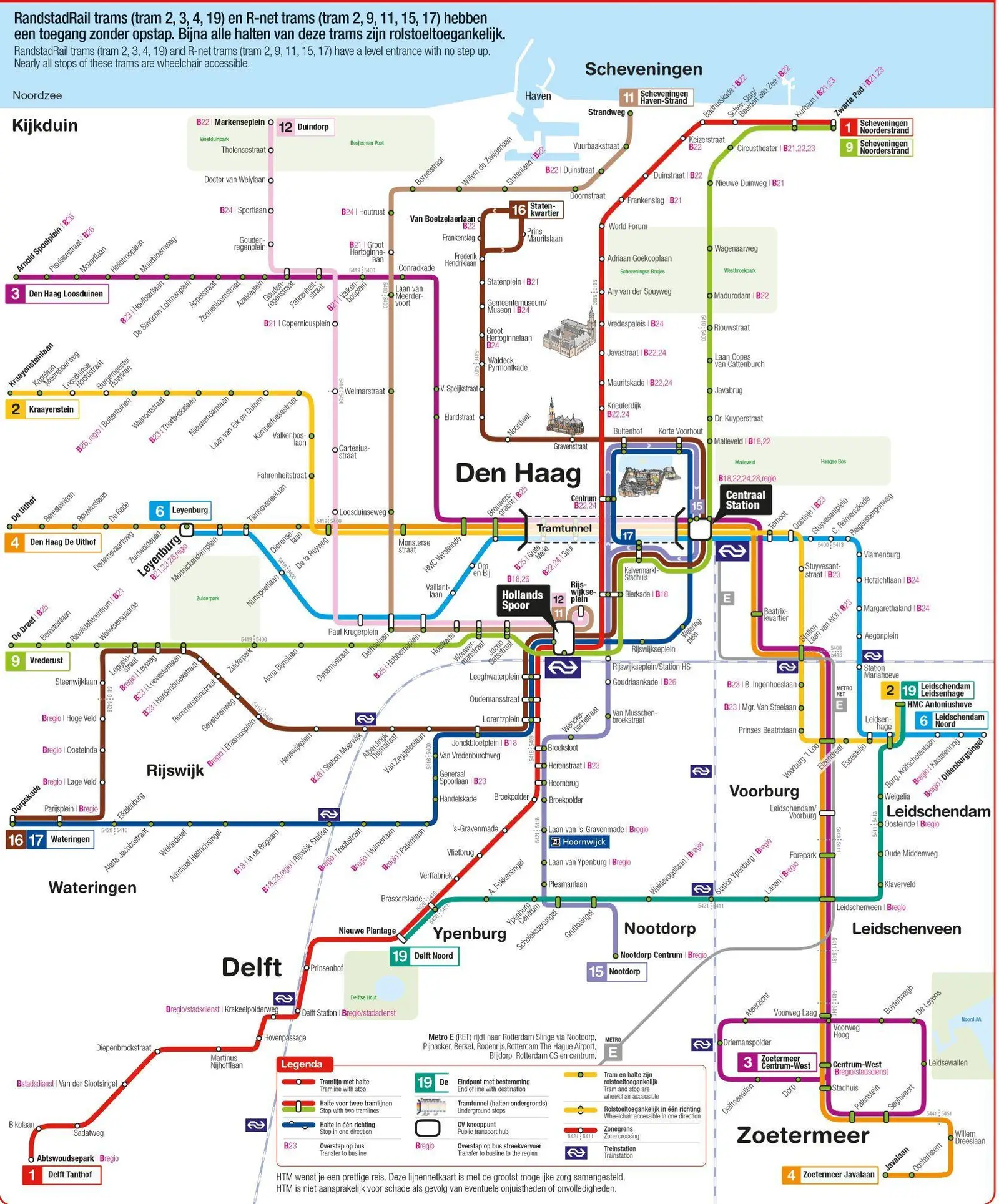
Click or tap the map to enlarge it.
Key Takeaways
- The Tram Map of The Hague is an essential tool for locals and tourists alike.
- It provides an efficient and convenient way to navigate the city’s tram network.
- The map showcases the various tram lines, their routes, and important stops.
- The Tram Map contributes to the overall accessibility and connectivity of The Hague.
History of the Tram Map in The Hague
The Tram Map of The Hague has a rich history that dates back to the introduction of the city’s first horse-drawn tram in 1864. Initially, the tram lines were not extensive, but as the city grew, so did the tram network.
In 1904, The Hague introduced its first electric tramline, which quickly replaced the horse-drawn trams. The expansion continued, and by the mid-20th century, the tram network covered a significant portion of the city. With each new line, the need for a comprehensive map became evident.
The first official Tram Map of The Hague was introduced in 1952. It depicted the existing lines, stops, and transfer points. Over the years, the map underwent several updates to accommodate changes in the tram network.
Unique Insights into the Tram Map
The Tram Map of The Hague holds valuable insights for both locals and visitors. Here are a few unique aspects:
- The map illustrates the well-structured zones designated for easier fare calculation.
- It highlights significant landmarks and attractions near tram stops for convenient exploration.
- The Tram Map showcases the integration of tram lines with other modes of public transportation, promoting seamless travel.
- It emphasizes accessibility, with clear symbols indicating wheelchair-friendly stops.
Table of Relevant Facts in The Hague’s Tram Map History
| Year | Event |
|---|---|
| 1864 | Introduction of The Hague’s first horse-drawn tram |
| 1904 | Transition to electric trams |
| 1952 | Introduction of the first official Tram Map of The Hague |
Frequently Asked Questions
1. How can I obtain a Tram Map of The Hague?
You can easily find Tram Maps at The Hague’s public transport information centers, tram stations, or download them online from the official city website.
2. Are the tram lines operational 24/7?
No, the tram network operates from early morning until midnight. However, limited night tram services are available on weekends.
3. Can I use the Tram Map for other forms of public transportation?
The Tram Map is primarily designed for tram routes, but it can also guide you in finding bus and train stations within The Hague.
4. Are there any discounted fare options available?
Yes, The Hague offers various smart card systems, such as the OV-chipkaart, which provides discounted fares and seamless transfers between different modes of transportation.
5. How often do tram routes change?
Tram routes may undergo changes due to city development plans or to improve connectivity. It is advisable to periodically check for updates on the official city transport website.
6. Are the Tram Maps available in multiple languages?
Yes, along with Dutch, the Tram Maps are available in English to cater to international visitors.
7. Can I take bicycles on trams?
Yes, you can bring your bicycle on specific trams during non-peak hours. However, be sure to consult the tram regulations for detailed guidelines.