Ww2 German Army Wehrmacht Uniforms Field Gray Mountain Tropical Mobile Troops Etc Newsmap Vol 2 No 40 19440124 Us Government National Archives Nara Unrestricted Public Domain 26Nm240 002
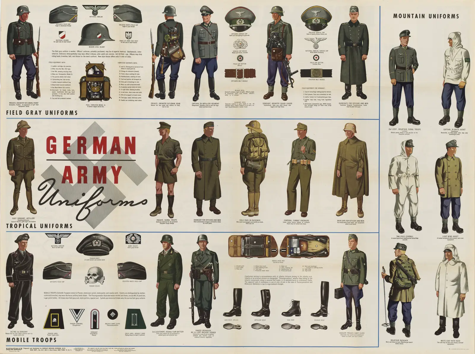
Click or tap the map to enlarge it.
Key Takeaways
- The Ww2 German Army Wehrmacht Uniforms Field Gray Mountain Tropical Mobile Troops map is a valuable resource for understanding the World War II era.
- This map provides detailed information about the different uniforms worn by the German Army during the war.
- The map is a fascinating historical artifact that offers insights into the organization and mobility of German troops.
- It is an excellent resource for historians, military enthusiasts, and individuals interested in World War II.
History
The Ww2 German Army Wehrmacht Uniforms Field Gray Mountain Tropical Mobile Troops map was published in Newsmap Vol 2 No 40 on January 24th, 1944. It was created by the US Government and is now part of the National Archives and Records Administration (NARA), available in the unrestricted public domain under the file name 26Nm240_002.
This map was produced during World War II to provide information and updates on the German Army’s uniforms and their various specialized divisions. It aimed to assist military personnel in identifying German soldiers based on their uniform variations.
Wehrmacht uniforms during World War II were known for their distinct features and a range of designs tailored for specific conditions. The variations included field gray uniforms for regular infantry, mountain troops, tropical uniforms for combat in hot climates, and specialized mobile troops attire.
Unique Insights
The Ww2 German Army Wehrmacht Uniforms Field Gray Mountain Tropical Mobile Troops map offers several unique insights into the uniforms worn by the German Army during World War II:
- The field gray uniforms were the standard attire for German soldiers and were worn by infantry units engaged in various combat operations.
- The mountain troops uniforms were designed specifically for soldiers serving in mountainous terrains, providing them with appropriate protection and camouflage.
- Tropical uniforms were suitable for combat in hot and humid climates, enabling German troops to operate effectively in regions with challenging environmental conditions.
- Mobile troops uniforms, characterized by their unique design, catered to the needs of fast-moving, mechanized divisions of the German Army.
- The map showcases the attention to detail and meticulous planning involved in developing specialized uniforms based on operational requirements.
- By studying the uniforms worn by German soldiers, historians can gather valuable insights into the strategies and tactics employed by the German Army during World War II.
- The map serves as a reminder of the significance of uniforms in military operations and their role in distinguishing and identifying different divisions and units.
Table of Relevant Facts
| Date | Publication | Creator | Availability |
|---|---|---|---|
| January 24th, 1944 | Newsmap Vol 2 No 40 | US Government | Unrestricted Public Domain (NARA) |
Frequently Asked Questions (FAQs)
-
What is the historical significance of this map?
This map holds significant historical value as it provides detailed information about the uniforms worn by the German Army during World War II. It offers insights into the organization, mobility, and specialization of German troops.
-
Who created this map?
The map was created by the US Government and was published in Newsmap Vol 2 No 40 on January 24th, 1944.
-
Where can I find the map?
The map is part of the National Archives and Records Administration’s collection and is available in the unrestricted public domain under the file name 26Nm240_002.
-
What types of uniforms are featured on this map?
The map showcases various uniforms worn by the German Army, including field gray uniforms, mountain troops uniforms, tropical uniforms, and mobile troops uniforms.
-
What purpose did this map serve during World War II?
This map was designed to assist military personnel in identifying German soldiers based on their uniform variations. It aimed to provide useful information about the German Army’s uniforms and specialized divisions.
-
Why are uniforms important in military operations?
Uniforms play a crucial role in military operations as they help distinguish and identify different divisions and units. They also provide soldiers with appropriate protection and camouflage tailored for specific conditions.
-
Who would find this map useful?
This map would be valuable to historians, military enthusiasts, researchers, and individuals interested in learning about the German Army’s uniforms during World War II.
External Links
- National Archives and Records Administration (NARA)
- Newsmap Vol 2 No 40 (PDF)
- Ww2 German Army Uniforms Article
LSI Keywords
- German Army uniforms
- Wehrmacht infantry attire
- Field gray uniforms
- Mountain troops uniforms
- Tropical mobile troops attire
- World War II uniforms
- Historical artifacts