Yangtze River Map
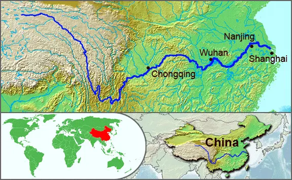
Click or tap the map to enlarge it.
Key Takeaways
- The Yangtze River is the longest river in Asia and the third longest river in the world.
- It plays a crucial role in China’s history, culture, and economy.
- The Yangtze River’s basin is home to numerous cities, including Shanghai, Wuhan, and Chongqing.
- The river hosts several natural and man-made attractions, making it a popular tourist destination.
- Understanding the Yangtze River map helps in appreciating its significance and exploring its diverse landscapes.
History
The Yangtze River has a rich history that spans thousands of years. Its strategic location and abundant resources have attracted civilizations and shaped the development of China. The river has witnessed the rise and fall of dynasties, the establishment of trade routes, and the growth of cities along its banks.
The earliest recorded history of the Yangtze River dates back to ancient times. It served as a transportation hub, allowing goods and people to move easily between different regions. As civilizations flourished, the river became an integral part of Chinese culture, inspiring poets, artists, and philosophers.
Unique Insights
1. Influence on Chinese Civilization: The Yangtze River has acted as a lifeline for the Chinese people, shaping their way of life and contributing to the growth of major cities.
2. Geographical Diversity: The river passes through various landscapes – from mountainous regions to fertile plains – offering a diverse range of natural beauty and ecosystems.
3. Economic Significance: The Yangtze River is a vital trade route, supporting industrial and agricultural activities that contribute to China’s economy.
4. Environmental Conservation: Environmental initiatives and preservation efforts have been undertaken to protect the river’s ecosystems and biodiversity.
Yangtze River Map Facts
| Fact | Description |
|---|---|
| Length | The Yangtze River spans approximately 6,300 kilometers (3,917 miles). |
| Source | The river originates from the Tanggula Mountains in Qinghai province. |
| Drainage Basin | The Yangtze River basin covers an area of 1,808,500 square kilometers (698,200 square miles). |
| Major Cities | Key cities along the river include Shanghai, Wuhan, Chongqing, and Nanjing. |
| Tributaries | Several major tributaries, including the Jialing River, Yalong River, and Min River, merge into the Yangtze. |
Frequently Asked Questions (FAQ)
1. What is the significance of the Yangtze River?
The Yangtze River holds immense significance for China as it has played a crucial role in its history, culture, and economy. It is often referred to as the cradle of Chinese civilization.
2. How long is the Yangtze River?
The Yangtze River stretches approximately 6,300 kilometers (3,917 miles) from its source in the Tanggula Mountains to its mouth at the East China Sea.
3. Which cities are located along the Yangtze River?
Several major cities, including Shanghai, Wuhan, Chongqing, and Nanjing, are situated along the Yangtze River.
4. Are there any attractions or landmarks along the river?
Yes, the Yangtze River is home to several attractions, such as the Three Gorges Dam, Fengdu Ghost City, and Zhangjiajie National Forest Park.
5. Is the Yangtze River important for transportation?
Absolutely, the Yangtze River serves as a crucial transportation route, facilitating trade and connecting various regions within China.
6. Are there any environmental concerns regarding the Yangtze River?
Yes, due to industrialization and human activities, environmental concerns such as pollution and habitat destruction have arisen. Efforts are being made to protect and conserve the river’s ecosystems.
7. Can I explore the Yangtze River through river cruises?
Yes, river cruises are a popular way to explore the Yangtze River and its surrounding attractions, allowing you to witness its scenic beauty and cultural heritage.