1907 Map of Asia Minoratlas of Ancient and Classical Geography by Samuel Butler
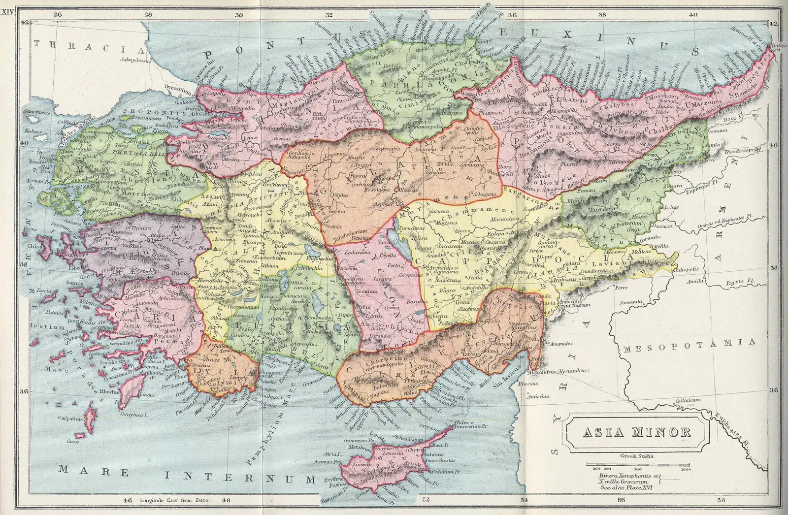
Click or tap the map to enlarge it.
Key Takeaways
- The 1907 Map of Asia Minor in the “Atlas of Ancient and Classical Geography” by Samuel Butler provides a detailed insight into the region’s geography during that time.
- The map depicts Asia Minor, also known as Anatolia, which was a significant cultural and historical region in ancient times.
- By studying this map, we can discover the ancient cities, major rivers, mountain ranges, and other important geographical features of Asia Minor.
- The “Atlas of Ancient and Classical Geography” is an invaluable resource for historians, archaeologists, and anyone interested in the ancient world.
History
The 1907 Map of Asia Minor, found in the “Atlas of Ancient and Classical Geography” by Samuel Butler, provides a glimpse into the geographical features of this historic region. Stretched between the Aegean Sea and the Black Sea, Asia Minor has a rich history dating back several millennia.
Unique Insights
- The map showcases the major cities of Asia Minor, such as Troy, Ephesus, and Pergamon, which were centers of ancient civilizations.
- It highlights the important rivers of the region, including the Halys, Hermus, and Maeander, which played significant roles in trade and transportation.
- The map also reveals the mountain ranges that dominate Asia Minor, such as the Taurus Mountains in the south and the Pontic Mountains in the north, providing insights into the region’s topography.
- Additionally, the map displays ancient regions within Asia Minor, such as Lydia, Phrygia, and Cappadocia, offering an understanding of the political and administrative divisions of the time.
Table of Relevant Facts
| Year | Event |
|---|---|
| 5000 BCE | The earliest known settlements appear in Asia Minor. |
| 1200 BCE | Trojan War, as described in Homer’s epic, “The Iliad,” takes place in Asia Minor. |
| 546 BCE | The Persians conquer Lydia, incorporating it into their empire. |
| 333 BCE | Alexander the Great defeats the Persians and begins the Hellenistic era in Asia Minor. |
| 133 BCE | The Roman Republic officially establishes the province of Asia in Asia Minor. |
| 395 CE | The Roman Empire splits, and Asia Minor becomes part of the Byzantine Empire. |
| 1071 CE | The Battle of Manzikert leads to the Seljuk Turks and other Turkic tribes establishing their presence in Asia Minor. |
| 1453 CE | The Byzantine Empire falls to the Ottoman Empire, marking the end of Byzantine rule in Asia Minor. |
Frequently Asked Questions (FAQ)
-
What is Asia Minor?
Asia Minor, also known as Anatolia, is a historical region located in present-day Turkey. It has played a crucial role in various ancient civilizations and empires throughout history.
-
Why is the “Atlas of Ancient and Classical Geography” relevant?
The “Atlas of Ancient and Classical Geography” by Samuel Butler is relevant because it provides detailed maps and information about ancient regions, including Asia Minor. It helps researchers and enthusiasts understand the historical and geographical context of the ancient world.
-
Which cities are depicted on the map?
The map displays major ancient cities such as Troy, Ephesus, Pergamon, and many others that were significant centers of trade, culture, and political power.
-
What are some prominent rivers found in Asia Minor?
The map highlights rivers like the Halys, Hermus, and Maeander. These rivers played important roles in the development of ancient civilizations, as they provided water for agriculture and facilitated trade.
-
What mountain ranges are present in Asia Minor?
The map reveals mountain ranges such as the Taurus Mountains in the south and the Pontic Mountains in the north. These mountainous regions influenced the region’s climate, settlement patterns, and trade routes.
-
What regions within Asia Minor are identified on the map?
The map identifies regions such as Lydia, Phrygia, Cappadocia, and others, highlighting the diverse political and administrative divisions within Asia Minor during ancient times.
-
Why is studying ancient geography important?
Studying ancient geography allows us to gain insights into the political, cultural, and economic dynamics of ancient civilizations. It helps unravel historical narratives and understand the challenges and opportunities those societies faced.