Indian Pacific Map
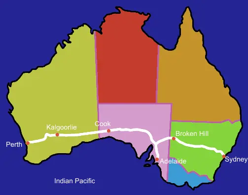
Click or tap the map to enlarge it.
Key Takeaways
- The Indian Pacific Map showcases the 4,352 km rail journey across Australia.
- It connects Sydney on the east coast with Perth on the west coast, traversing through diverse landscapes.
- The map offers a unique perspective of the vastness and beauty of Australia.
- Traveling the Indian Pacific route offers an unforgettable experience of the continent’s culture and history.
- The map serves as a valuable resource for planning and exploring the diverse regions of this remarkable country.
History of the Indian Pacific Map
The Indian Pacific Map traces its roots back to the establishment of the transcontinental railway in Australia. The ambitious project aimed at connecting the eastern and western coasts of the vast continent. After several years of planning and construction, the Indian Pacific rail service was inaugurated in 1970.
Soon after its launch, the Indian Pacific gained recognition as one of the world’s greatest rail adventures, securing its place as an iconic Australian journey. Capturing the imagination of travelers, the map was introduced to provide an overview of the entire route, depicting major stops, tourist attractions, and distinctive landscapes.
Unique Insights
1. Awe-Inspiring Landscapes
The Indian Pacific Map showcases the diverse landscapes the train journey traverses. Passengers are treated to breathtaking sights including the majestic Blue Mountains, the barren expanse of the Nullarbor Plain, and the magnificent Flinders Ranges. From vast deserts to rolling hills, this map highlights the ever-changing beauty of Australia’s landscape.
2. Cultural Encounters
During the journey, passengers have the opportunity to disembark at various stops and explore the rich culture of different towns and cities. From learning about indigenous traditions to experiencing the vibrant urban life in Perth and Sydney, the Indian Pacific Map serves as a guide to help travelers immerse themselves in the local culture.
3. Historical Significance
History buffs will appreciate the chance to disembark at Broken Hill, a town with a rich mining heritage, or the picturesque town of Cook, which offers a glimpse into the challenges faced by early settlers. The Indian Pacific Map includes details about these historical landmarks and ensures that passengers don’t miss out on these fascinating parts of Australia’s past.
Table of Relevant Facts
| Year | Event |
|---|---|
| 1867 | Initial proposals for a transcontinental railway system across Australia were made. |
| 1917-1930 | Construction work commenced in stages. |
| 1970 | The Indian Pacific railway service was officially launched. |
| 1980 | First electrified section of the line was completed. |
| 2007 | Queen Elizabeth II became the first reigning monarch to travel on the Indian Pacific. |
Frequently Asked Questions (FAQ)
1. How long does the Indian Pacific journey take?
The entire journey from Sydney to Perth, or vice versa, takes approximately 65 hours.
2. Are there stops along the Indian Pacific route?
Yes, the train makes various stops including Broken Hill, Adelaide, and Kalgoorlie, allowing passengers to explore these destinations.
3. What is the best time to travel on the Indian Pacific?
The Indian Pacific operates throughout the year, but the best time to travel depends on personal preferences. Spring and autumn are popular for pleasant weather and vibrant landscapes.
4. Does the train offer comfortable accommodation?
Absolutely! The Indian Pacific provides a range of comfortable accommodation options, from sleeper cabins to luxury suites.
5. Are meals included on the journey?
Yes, all meals and beverages are included in the ticket price. Passengers can enjoy delicious cuisine prepared by onboard chefs.
6. Is Wi-Fi available on the train?
While Wi-Fi is not currently available on the Indian Pacific, the journey offers an opportunity to disconnect and appreciate the beauty of the surroundings.
7. Can I bring my car on the Indian Pacific?
No, passengers cannot bring their cars on the Indian Pacific. However, there are options to transport vehicles separately if needed.