Oudh in Northern India, 1857: Map
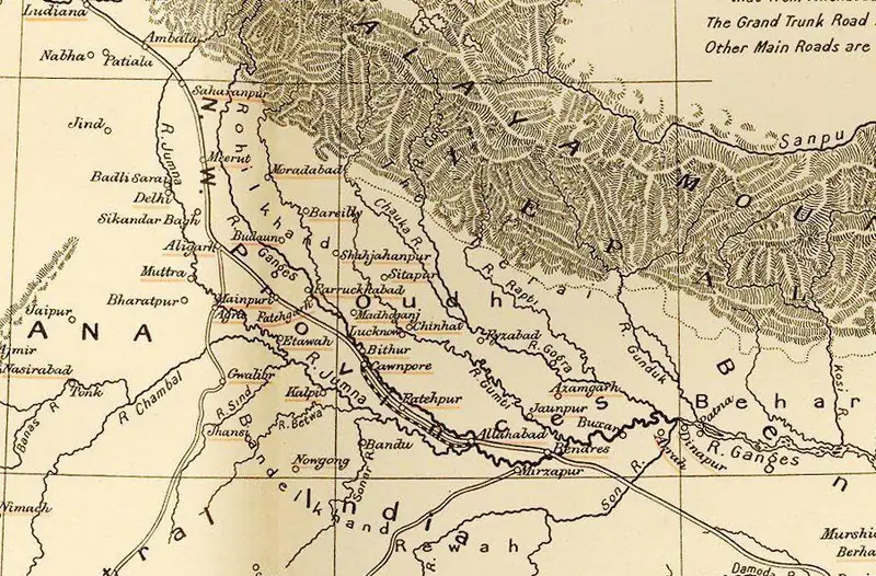
Click or tap the map to enlarge it.
This map of Oudh in northern India, published by Stanford's Geographical Establishment in London and now in the public domain, shows the kingdom whose annexation and fall were closely tied to the great rebellion of 1857.
Oudh, also spelled Awadh, lay between the Ganges and the Himalayan foothills, with Lucknow as its capital. It was one of the richest and most populous regions of northern India.
Annexation and rebellion
The East India Company annexed Oudh in February 1856 on the grounds of misgovernment, deposing the Nawab Wajid Ali Shah. The takeover angered the landholding class and the many sepoys recruited from Oudh villages. When soldiers at Meerut mutinied on 10 May 1857, the revolt spread rapidly, and Oudh became one of its main centres. Lucknow was besieged from the summer, with the British Residency defended for months until relief forces arrived in November.
The rebel court was led by Begum Hazrat Mahal, who ruled in the name of her young son Birjis Qadr.
Reconquest and aftermath
British forces under Sir Colin Campbell retook Lucknow in March 1858, and fighting in Oudh's countryside continued into 1859. The rebellion led to the transfer of the Company's powers to the British Crown in 1858. Oudh was later merged with the North-Western Provinces to form the United Provinces of Agra and Oudh in 1902, the forerunner of today's Uttar Pradesh.
Key facts
| Date | Event |
|---|---|
| February 1856 | East India Company annexes Oudh |
| 10 May 1857 | Mutiny begins at Meerut |
| Summer to November 1857 | Siege and relief of the Lucknow Residency |
| March 1858 | British retake Lucknow |
| 1858 | Company rule replaced by Crown rule |
| 1902 | United Provinces of Agra and Oudh formed |
Questions about this map
Where was Oudh?
In what is now central and eastern Uttar Pradesh, with Lucknow as its centre.
What else is the 1857 revolt called?
It is known as the Indian Rebellion of 1857, the Sepoy Mutiny, or in Indian history the First War of Independence.
Is Oudh the same as Ayodhya?
No. Ayodhya is a city that was an early capital of the Nawabs of Awadh, but the region was much larger.