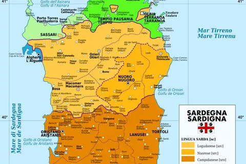
Sardinia Map
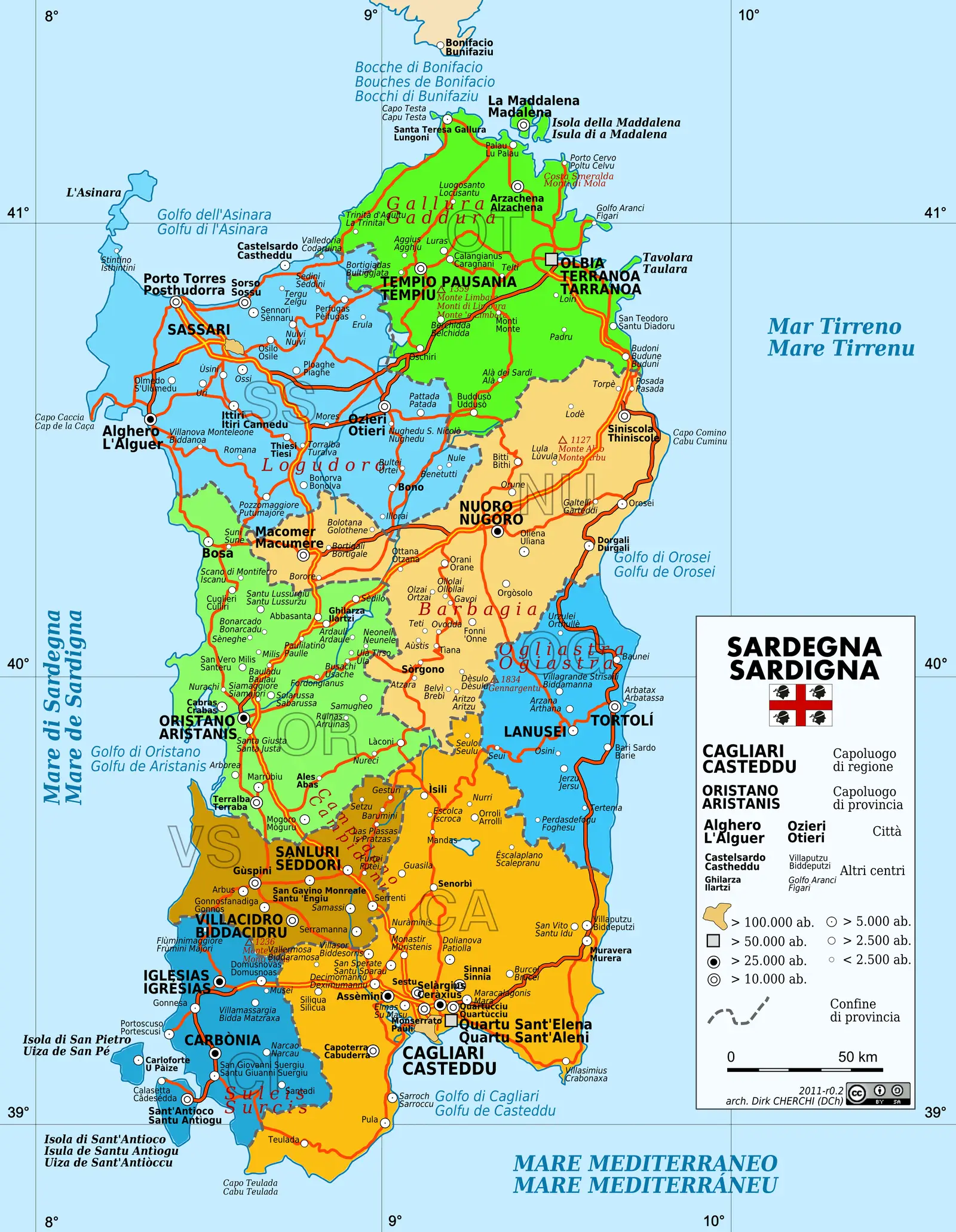
Click or tap the map to enlarge it.
Sardinia Map: Exploring the Beauty of Italy’s Gem
Key Takeaways
- Sardinia, an island in the Mediterranean Sea, boasts stunning natural landscapes and rich cultural heritage.
- The Sardinia Map showcases the island’s diverse regions, including beautiful beaches, historical sites, and vibrant
cities. - Exploring the Sardinia Map helps plan an adventure to discover hidden gems and indulge in authentic Italian
experiences.
History
Sardinia, the second-largest island in the Mediterranean after Sicily, has a captivating history that dates back to
prehistoric times. It has witnessed the rule of various civilizations, including the Phoenicians, Romans,
Byzantines, Arabs, and Spanish.
With such a rich historical background, studying the Sardinia Map allows travelers to trace the remnants of these
ancient civilizations through numerous archaeological sites and monuments.
Unique Insights
While exploring the Sardinia Map, you will come across several unique insights:
- Sardinia is home to some of the most beautiful beaches in the world, with crystal-clear waters and pristine
white sand. - The island has a mountainous interior, providing opportunities for hiking and panoramic views.
- Sardinian cuisine is renowned for its rich flavors, including dishes such as culurgiones (stuffed pasta),
porceddu (roast piglet), and seadas (honey and cheese pastry). - The Nuragic civilization, which flourished in Sardinia from the Bronze Age, left behind intriguing megalithic
structures called nuraghe.
Sardinia Map: Quick Facts
| Year | Event |
|---|---|
| 259–253 BC | Sardinia becomes a Roman province. |
| 456–534 AD | Sardinia is under Byzantine rule. |
| 9th–10th centuries | Sardinia is invaded by Arab forces. |
| 1323–1720 | Sardinia is part of the Crown of Aragon. |
| 1720–1861 | Sardinia is ruled by various Piedmontese dynasties. |
FAQ about Sardinia Map
1. How do I reach Sardinia?
Sardinia is accessible by air, with international airports located in Cagliari, Olbia, and Alghero. Ferries from
mainland Italy also serve as a transportation option.
2. What are the must-visit regions in Sardinia?
Sardinia offers diverse regions, each with its own charm. The must-visit regions include the stunning Costa Smeralda,
the cultural hub of Cagliari, the historic city of Alghero, and the unspoiled beauty of the Maddalena Archipelago.
3. Are there any UNESCO World Heritage sites in Sardinia?
Yes, Sardinia is home to several UNESCO World Heritage sites, such as the archaeological sites of Su Nuraxi di
Barumini and the prehistoric necropolis of Anghelu Ruju.
4. What outdoor activities can be enjoyed in Sardinia?
Sardinia provides a wealth of outdoor activities, including hiking, snorkeling, diving, sailing, and exploring the
mesmerizing caves along its coastline.
5. Is it necessary to rent a car to explore Sardinia?
Renting a car is highly recommended to explore Sardinia fully. It provides the flexibility to visit remote areas and
experience the island’s true beauty at your own pace.
6. What is the best time to visit Sardinia?
The best time to visit Sardinia is during spring (April-May) and autumn (September-October) when the weather is mild
and the tourist crowds are thinner.
7. Are there any unique festivals in Sardinia?
Yes, Sardinia celebrates various unique festivals, such as the colorful Sartiglia in Oristano, the La Cavalcata
Sarda in Sassari, and the Sant’Efisio procession in Cagliari.