Vichy France Map
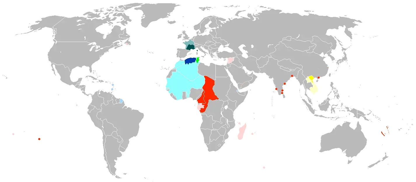
Click or tap the map to enlarge it.
Vichy France Map: A Comprehensive Guide
Key Takeaways
- Vichy France was a puppet state established in World War II.
- This map provides an overview of the areas controlled by Vichy France.
- Understanding the geography of Vichy France is crucial to comprehending the complexities of the era.
- Exploring the historical context of Vichy France enriches our knowledge of World War II.
History: Vichy France
Vichy France was a government that existed during World War II from 1940 to 1944. The state was established in
the southeastern part of France after the German invasion and subsequent division of the country. Vichy France
was led by Marshal Philippe Pétain, a French World War I hero.
The Vichy regime collaborated with Nazi Germany and adopted a policy that significantly repressed political
opposition and persecuted certain groups, including Jews. The control and influence of Vichy France extended
beyond mainland France, covering French territories and colonies around the world.
Unique Insights
- Vichy France controlled a large portion of French territories, including colonies in Africa, Asia, and the
Pacific. - The Vichy government actively collaborated with Nazi Germany in the extermination of Jews and the persecution
of political opponents. - Resistance movements against the Vichy regime played a crucial role in the liberation of France.
- The end of Vichy France came with the Allied invasion of Normandy and subsequent liberation in 1944.
Vichy France Map Facts
| Year | Event |
|---|---|
| 1940 | The establishment of Vichy France as a puppet state. |
| 1942 | Vichy France conducted the Vel’ d’Hiv Roundup, deporting over 13,000 Jews. |
| 1944 | Vichy France dissolved as Allied forces liberated the country. |
Frequently Asked Questions
-
What was Vichy France?
Vichy France was a puppet state established in 1940 during World War II. It collaborationist government
controlling areas of France and French territories. -
Who was the leader of Vichy France?
Martial Philippe Pétain, a French World War I hero, led Vichy France.
-
How did Vichy France collaborate with Nazi Germany?
Vichy France collaborated with Nazi Germany in various ways, including the repression of political opposition
and persecution of Jews. -
Where was Vichy France located?
Vichy France was predominantly located in the southeastern part of France. However, it also controlled
French territories and colonies worldwide. -
What was the role of resistance movements in Vichy France?
Resistance movements played a significant role in opposing the Vichy regime and ultimately contributed to the
liberation of France. -
How did Vichy France come to an end?
Vichy France came to an end in 1944 with the Allied invasion of Normandy and the subsequent liberation of
France. -
What impact did Vichy France have on World War II?
Vichy France’s collaboration with Nazi Germany had a significant impact on the political landscape of World
War II. The establishment of the Vichy regime enabled Germany to maintain control over a substantial part of
France.
External Links
LSI Keywords
- Vichy France history
- Vichy regime
- World War II collaboration
- Controlled territories of Vichy France
- Vichy France resistance movements
- Liberation of France
- Vichy France’s impact on World War II