Vichy France Map
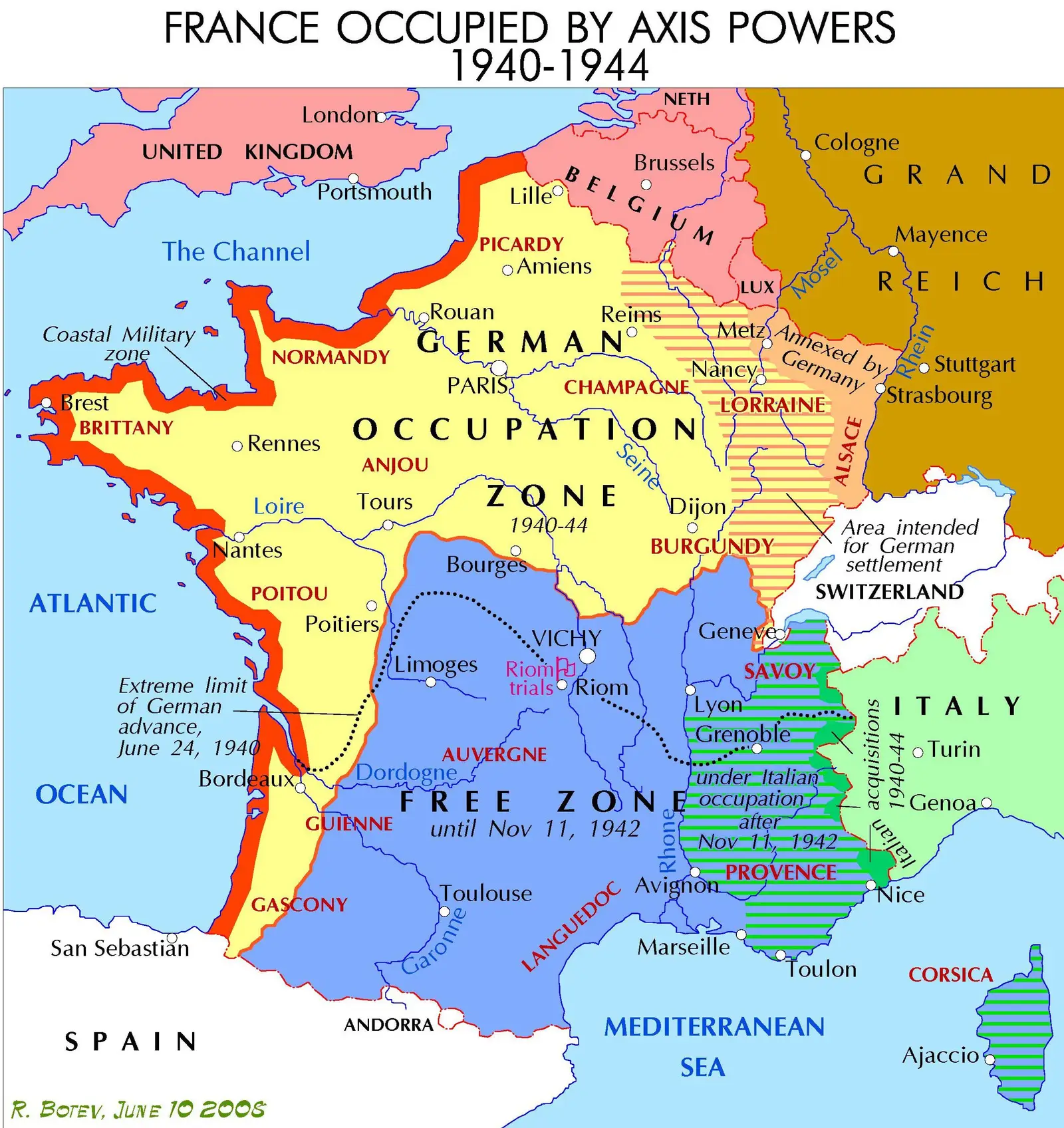
Click or tap the map to enlarge it.
Vichy France Map – A Detailed Overview of World War II Era
Key Takeaways
- Vichy France was a collaborationist regime formed during World War II.
- It controlled the southern part of France while the northern part was occupied by Nazi Germany.
- The Vichy France map highlights the areas that fell under the control of this regime.
- It played a complex role in the history of the war and its aftermath.
- The map serves as a historical reference for understanding the geopolitical landscape of that time.
History
The Vichy France map encompasses the territory controlled by the French government led by Marshal Philippe Pétain during World War II. Following the German invasion of France in June 1940, a new regime was established in Vichy, a small town in central France.
The Vichy regime collaborated with Nazi Germany and controlled the unoccupied southern part of France, leaving the northern part under direct German occupation. The regime aimed to maintain sovereignty over French territories and aligned itself with the Axis Powers.
However, the Vichy government’s authority was tenuous, and many French citizens resisted Vichy’s collaborationist policies. As the war progressed, the influence of the Vichy regime diminished, and it eventually came to an end when the Allies liberated France in 1944.
Unique Insights
1. Dual Control – Nazi Germany and Vichy France
The Vichy France map showcases the division of France during World War II. While the northern part was directly occupied by Nazi Germany, the southern part remained under the control of the Vichy regime. This division contributed to the complexities of the war and the resistance movements that emerged.
2. Collaborationist Policies
The Vichy government implemented various collaborationist policies to maintain its control and appease Nazi Germany. This included enacting anti-Semitic measures and assisting in the deportation of Jews to concentration camps. The Vichy France map serves as a grim reminder of these dark times.
3. Resistance Movements
The Vichy France map also highlights the territories where resistance movements against the collaborationist regime operated. These resistance groups played a crucial role in undermining Vichy’s authority and preparing the ground for the liberation of France by the Allies.
Table of Relevant Facts
| Year | Event |
|---|---|
| 1940 | German invasion and establishment of Vichy regime |
| 1942 | German occupation of the Free Zone in Vichy France |
| 1944 | Allied liberation of France |
Frequently Asked Questions (FAQ)
1. What was Vichy France?
Vichy France refers to the collaborationist regime led by Marshal Philippe Pétain that controlled the southern part of France during World War II.
2. How long did Vichy France exist?
The Vichy regime existed from 1940 to 1944.
3. What was the role of Vichy France during World War II?
Vichy France collaborated with Nazi Germany and implemented policies dictated by the German occupation. It aimed to maintain a semblance of French sovereignty while supporting the Axis Powers.
4. Did Vichy France have any resistance movements?
Yes, there were various resistance movements operating within the territories controlled by the Vichy regime. They played a crucial role in undermining Vichy’s authority and preparing for the liberation of France.
5. How did Vichy France come to an end?
Vichy France came to an end when the Allies liberated France in 1944, during the later stages of World War II.
6. Were there any consequences for the collaborationist regime after the war?
After the war, many high-ranking officials of the Vichy regime were tried for collaboration and war crimes. Marshal Philippe Pétain was sentenced to death, which was later commuted to life imprisonment.
7. Why is the Vichy France map significant?
The Vichy France map serves as an important historical reference for understanding the geopolitical division and complexities during World War II. It helps depict the areas controlled by the collaborationist regime and the territories under German occupation.