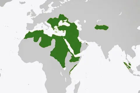
Map of the Ottoman Empire in 1900
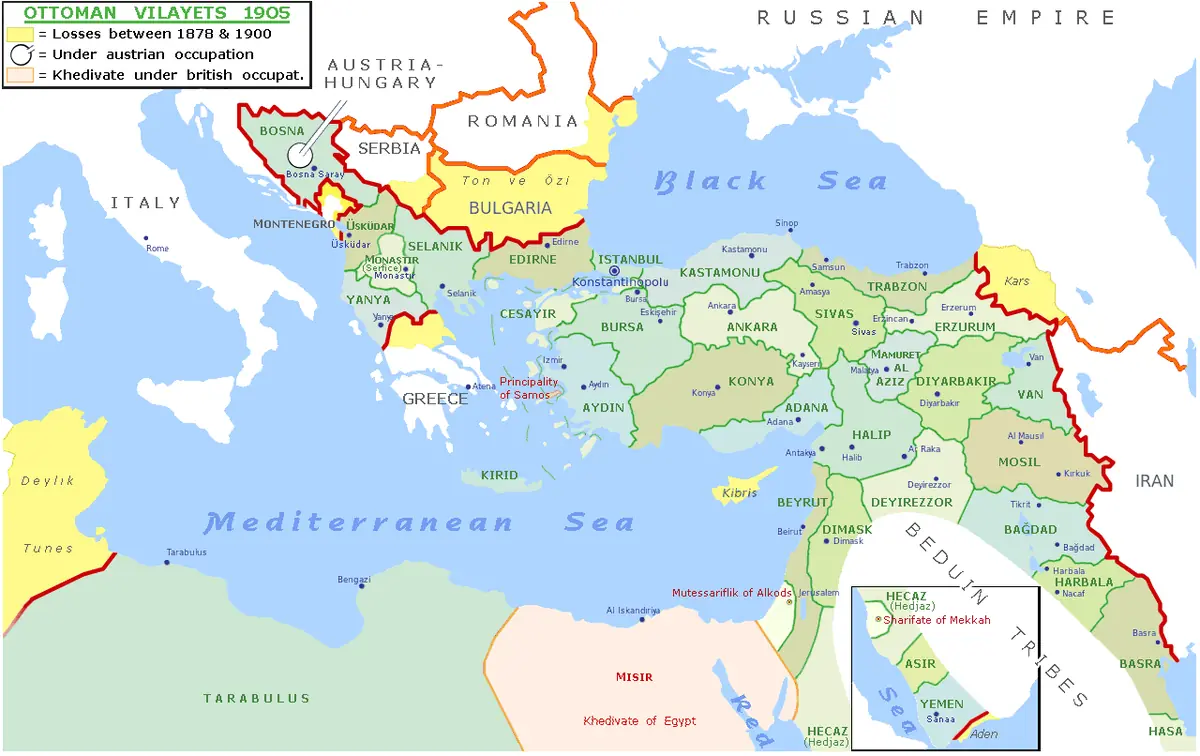
Click or tap the map to enlarge it.
This map shows the extent of the Ottoman Empire around 1900, drawn over modern country borders so the territory can be compared with today's map. By that date the empire had been shrinking for more than two centuries.
The Ottoman state began as a small principality in north-western Anatolia around 1300 and grew to control south-eastern Europe, western Asia and North Africa. Its capital, Constantinople, was taken from the Byzantines in 1453.
What the empire still held in 1900
By 1900 the Ottoman Empire's European territory was reduced to a strip including Eastern Thrace, Macedonia and Albania, following losses to Russia and the Balkan states at the Congress of Berlin in 1878 and earlier. In Asia it held Anatolia, Syria, Mesopotamia and the Arabian coast along the Red Sea, including Mecca and Medina. In Africa it kept Tripolitania in what is now Libya, while Egypt, though nominally Ottoman, was under British occupation from 1882.
The map shows an empire still very large, but with borders defined by European great-power diplomacy rather than by Ottoman choice.
From reform to collapse
The Tanzimat reforms of 1839 to 1876 tried to modernise the army, law and administration. Sultan Abdulhamid II suspended the first constitution in 1878, and the Young Turk revolution restored it in 1908. Wars in Libya and the Balkans in 1911 to 1913 stripped away most remaining European and African land. The empire entered the First World War in 1914 on the side of Germany; the sultanate was abolished in November 1922 and the Republic of Turkey was proclaimed on 29 October 1923.
Key facts
| Year | Event |
|---|---|
| c. 1300 | Ottoman principality emerges in north-western Anatolia |
| 1453 | Constantinople captured by Mehmed II |
| 1520-1566 | Reign of Suleiman the Magnificent |
| 1878 | Congress of Berlin redraws Balkan borders |
| 1908 | Young Turk revolution |
| 1922-1923 | Sultanate abolished; Turkish Republic proclaimed |
Questions about this map
When was the Ottoman Empire at its largest?
In the 16th and 17th centuries, well before the date shown on this map.
Why draw it over modern borders?
Overlaying the 1900 territory on today's countries makes it easier to see which present-day states were once Ottoman.
When did the empire end?
The sultanate was abolished in 1922 and the Republic of Turkey followed in 1923.