Singapore Old MRT Map
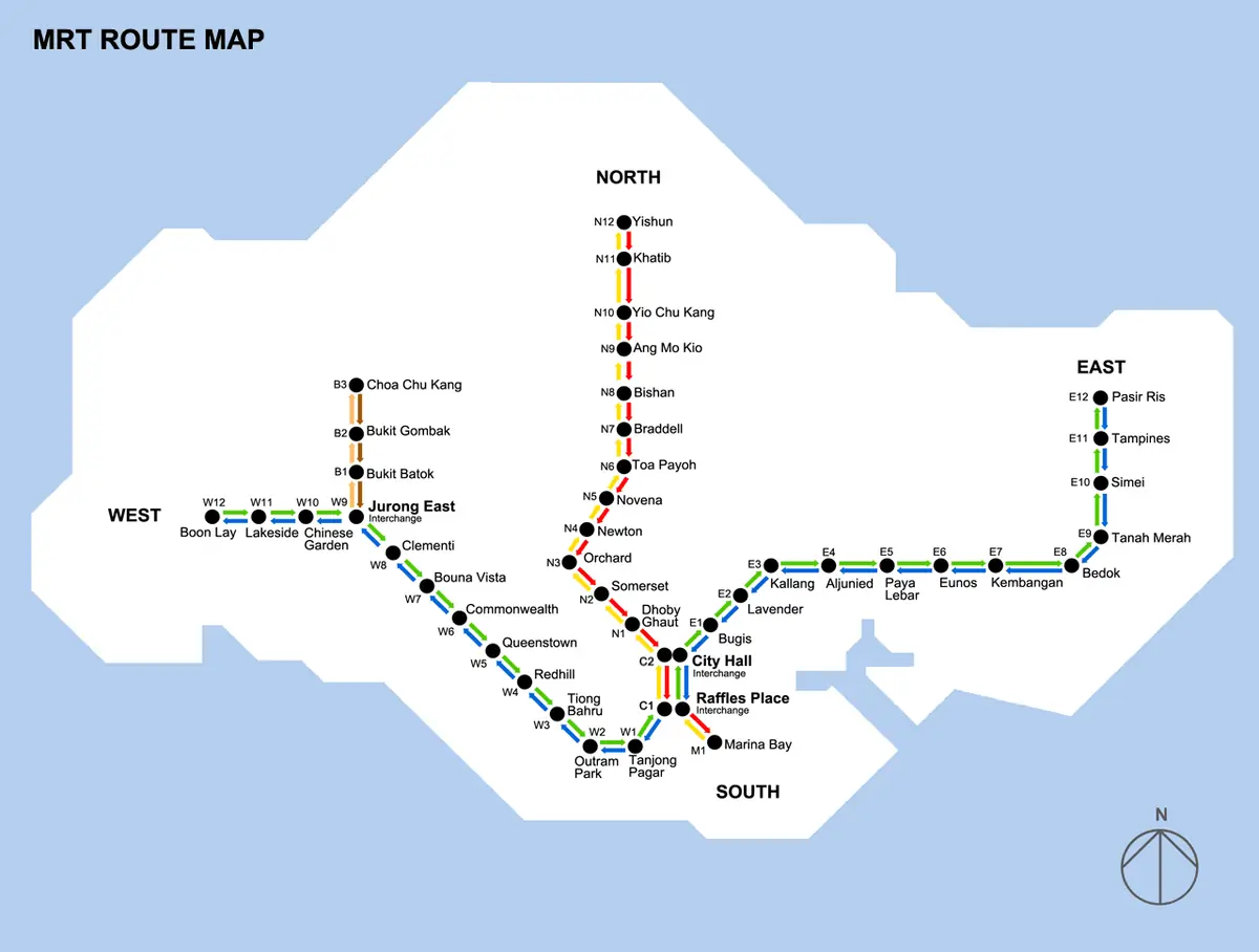
Click or tap the map to enlarge it.
This route diagram shows Singapore's Mass Rapid Transit network as it stood in the early 1990s, with lines running north to Yishun, east to Pasir Ris and west to Boon Lay, and interchanges at City Hall and Raffles Place. It is useful for seeing how much the system has grown since.
Singapore's MRT opened on 7 November 1987 with a short section from Yio Chu Kang to Toa Payoh, about 6 kilometres and five stations.
The first network
The original system was built as two main routes, the North-South Line and the East-West Line, which share the central stations at City Hall and Raffles Place so passengers can change trains. In the late 1980s the lines were extended step by step, east to Pasir Ris and west to Boon Lay, until the initial network was completed in 1990. Station codes on today's maps, such as NS and EW, preserve this structure.
The diagram has no Woodlands extension, no Circle Line loop, no Downtown Line and no Thomson-East Coast Line, so many suburban areas now served by rail are blank.
How the network expanded
The North East Line opened in 2003 as Singapore's first fully automated underground line. The Circle Line opened in stages from 2009 and was completed in 2011, joining the radial lines. The Downtown Line opened in stages from 2013 to 2017, and the Thomson-East Coast Line began opening in 2020. Comparing the old map with a current one is a quick way to read changes in the city's development.
Key facts
| Year | Event |
|---|---|
| 1987 | First section opens, Yio Chu Kang to Toa Payoh |
| 1990 | Initial North-South and East-West network completed |
| 2003 | North East Line opens |
| 2009-2011 | Circle Line opens in stages |
| 2013-2017 | Downtown Line opens in stages |
| 2020 | Thomson-East Coast Line begins opening |
Questions about this map
When did the MRT open?
On 7 November 1987.
Which lines does the old map show?
The north-south and east-west routes of the early network. Later lines do not appear.
Is the old map used for navigation?
No. It is historical; use the current network map for planning journeys.