Grand Canyon South Rim Pocket Map (NPS)
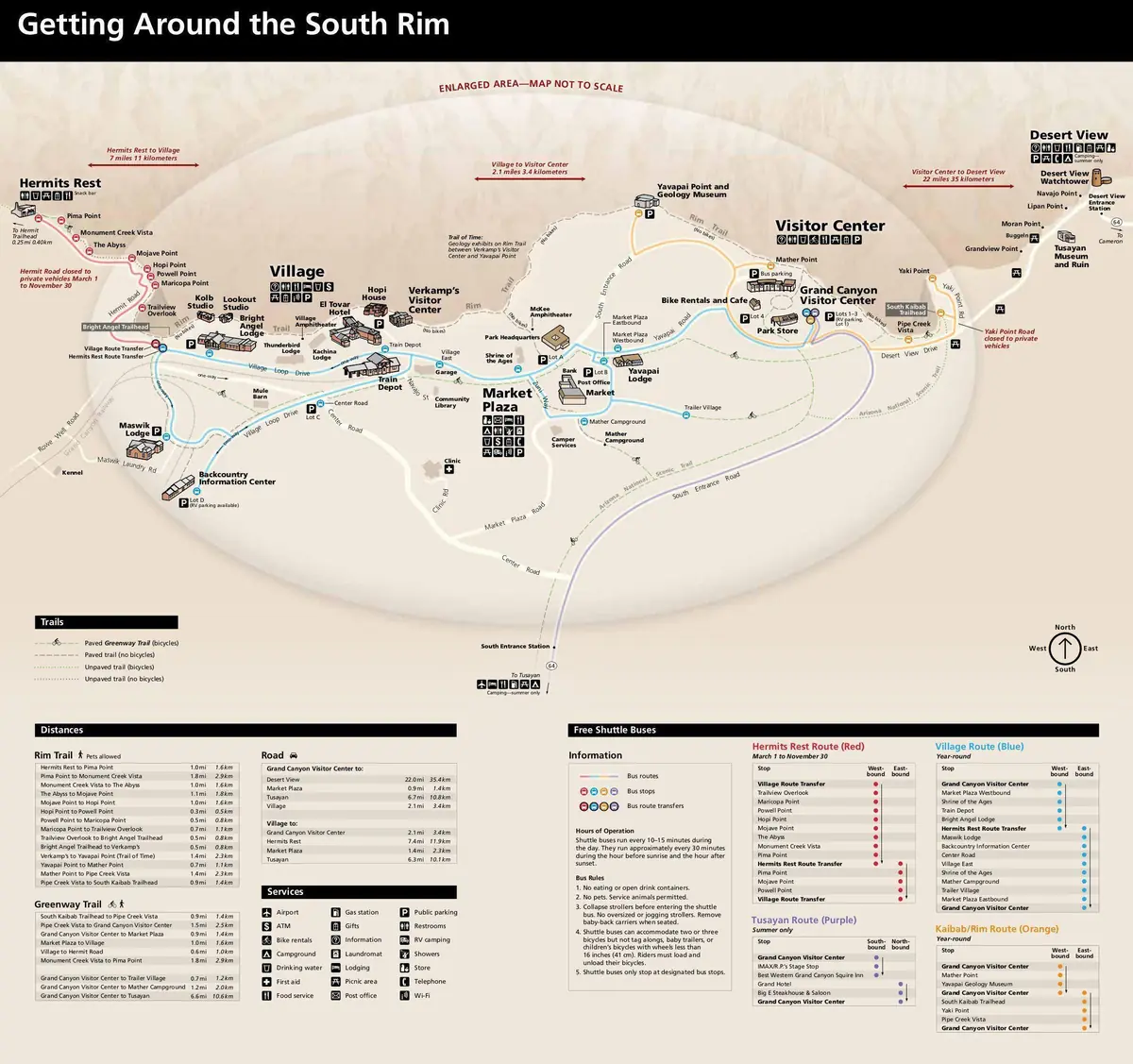
Click or tap the map to enlarge it.
This pocket map, published by the U.S. National Park Service, shows the South Rim of Grand Canyon National Park in Arizona with its lodges, visitor facilities, shuttle bus routes and points of interest. Pocket maps are designed to be folded and carried on the trail.
The canyon is 277 river miles long, up to 18 miles wide and more than a mile deep, and the South Rim sits at about 7,000 feet above sea level.
What a park map shows
A good park map is both a navigation aid and a planning tool. The South Rim map shows the Grand Canyon Village area, Hermit Road, Desert View Drive and the shuttle routes that serve them, as well as trailheads for the Bright Angel and South Kaibab Trails. Distances and elevation changes are important in a canyon where the walk down is optional but the walk back up is not.
Grand Canyon became a national monument in 1908 and a national park in 1919, and it has been a UNESCO World Heritage Site since 1979.
Public-domain government maps
National Park Service maps are works of the US federal government and are in the public domain. They are free to reuse, although they are updated as trails and services change. Check the park's website for the current version before planning a trip.
Using the map on the South Rim
Free shuttle buses link the Village, the South Kaibab trailhead and Hermit Road, and Desert View Drive runs about 25 miles east to the Desert View Watchtower, built in 1932 to a design by Mary Colter. The Bright Angel Trail descends about 9.5 miles to the Colorado River. Rangers strongly advise against hiking from the rim to the river and back in a single day, especially in summer, because of the heat and the climb.
Key facts
| Fact | Detail |
|---|---|
| State | Arizona |
| National park since | 1919 |
| UNESCO World Heritage Site since | 1979 |
| Canyon length | 277 river miles |
| Depth | More than a mile |
Questions about this map
What is the South Rim?
The side of the canyon with the most visitor services, open all year.
Are there shuttles?
Yes, free shuttle buses run on several routes in the park.
Can I walk to the river?
Yes, but it is a strenuous trip; follow park guidance.