Johann Homann’s Map of the Solar System (1716)
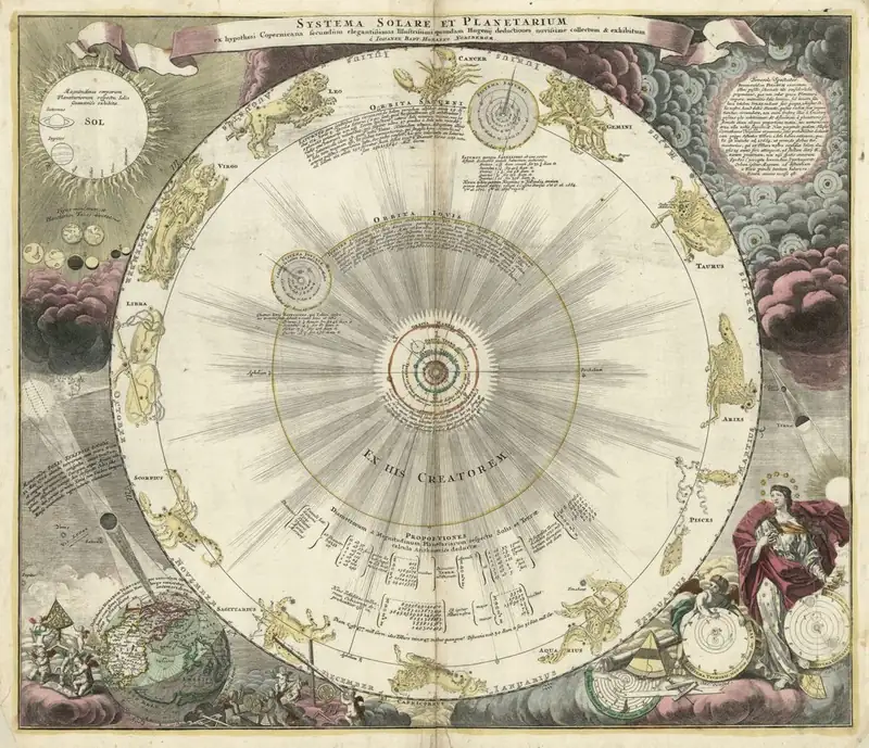
Click or tap the map to enlarge it.
This engraved chart of the solar system, published by Johann Baptist Homann of Nuremberg and dated 1716, shows the Sun at the centre with the planets circling it in the Copernican arrangement. Around the diagram are the signs of the zodiac, smaller diagrams and decorative figures.
Its Latin title translates roughly as 'The Solar System and the Planets according to the Copernican hypothesis', with a reference to the calculations of Christiaan Huygens.
A heliocentric diagram in a map shop
Homann ran one of the largest map publishing houses in Germany. Many of his products were maps of lands, but he also published celestial charts, which were popular among educated buyers. The planets are drawn on concentric circles. By 1716 astronomers knew of four moons of Jupiter and several of Saturn, discovered in the previous century. Galileo found four moons of Jupiter in 1610, and Huygens discovered Saturn's largest moon, Titan, in 1655.
By 1716 the heliocentric model, proposed by Copernicus in 1543, was widely accepted by astronomers, although religious and academic debates continued.
Why it belongs on a map site
Maps of the heavens use many of the same tools as maps of the earth: scale, orientation and projection. The border decorations, cartouches and engraving style are typical of Homann's workshop, and the sheet has a place in the history of both astronomy and cartography.
Homann's firm
Johann Baptist Homann founded his publishing house in Nuremberg in 1702. In 1715 he was appointed Imperial Geographer to the Holy Roman Emperor and was elected to the Prussian Royal Academy of Sciences. After his death in 1724 the business continued as Homann Heirs until the early nineteenth century. The firm's maps and celestial charts were widely copied, and they remain popular with collectors today.
Key facts
| Fact | Detail |
|---|---|
| Publisher | Johann Baptist Homann, Nuremberg |
| Date | 1716 |
| Model shown | Copernican, with the Sun at the centre |
| Copernicus's book | 1543 |
| Titan discovered by Huygens | 1655 |
Questions about this map
Who was Homann?
A German geographer and publisher who founded a map-making house in Nuremberg.
What does Copernican mean?
A model in which the planets, including the Earth, orbit the Sun.
Is the original public domain?
Yes, it is an early eighteenth-century work.