Integrated Chicago Districts Map
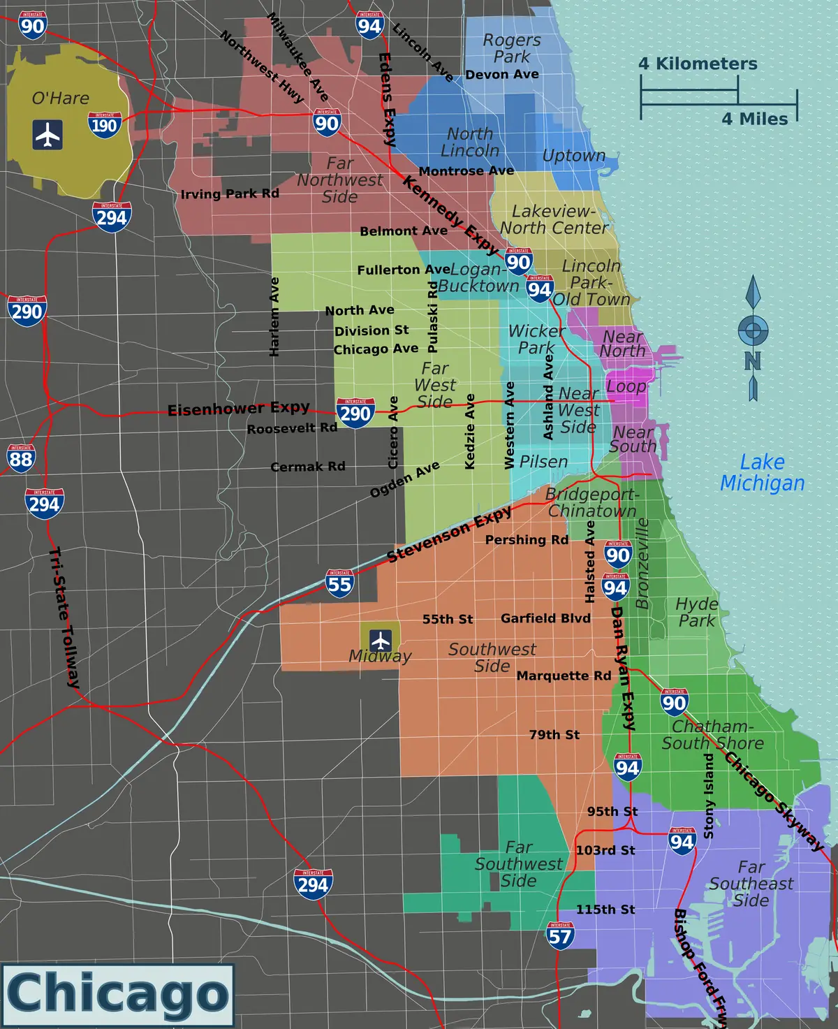
Click or tap the map to enlarge it.
This map divides Chicago into colour-coded districts, names neighbourhoods such as Lincoln Park and Lakeview, and overlays the expressway network. Major expressways such as I-90, I-94, I-55 and I-290 act as dividers between the districts.
Chicago had a population of about 2.7 million at the 2020 census, making it the third-largest city in the United States after New York and Los Angeles.
Districts, community areas and neighbourhoods
Chicago uses several overlapping systems. The city has 77 official community areas, which were defined in the 1920s by researchers at the University of Chicago and are used for statistics. Residents more commonly refer to about 200 neighbourhoods and to broad sides of the city, such as the North, West and South Sides. A district map like this one simplifies this into larger zones.
The expressways shown are part of the Interstate system and radiate from the downtown Loop.
The street grid
Chicago's addresses are based on a grid whose origin is the intersection of State and Madison Streets in the Loop. A number such as 800 North is eight blocks north of Madison Street, and every eight blocks make a mile, which helps visitors estimate walking distances. The city lies on the south-western shore of Lake Michigan and was incorporated as a city in 1837.
Expressways and the river
The expressways on the map include the Dan Ryan and Kennedy (I-90 and I-94), the Stevenson (I-55) to the south-west and the Eisenhower (I-290) to the west. Most were built in the 1950s and 1960s. The Chicago River, which runs through the Loop, had its flow reversed in 1900 so that it drains away from Lake Michigan, the city's source of drinking water. Both the river and the lakefront are major organising features of the city's geography.
Key facts
| Fact | Detail |
|---|---|
| Population (2020 census) | About 2.7 million |
| Official community areas | 77 |
| Incorporated as a city | 1837 |
| Address grid origin | State and Madison Streets |
| Lake | Lake Michigan |
Questions about this map
How many neighbourhoods does Chicago have?
There are about 200 informally, and 77 official community areas.
What is the Loop?
The central business district, encircled by elevated train tracks.
Why is the grid useful?
Addresses show distance from the origin, so you can estimate how far a place is.