Clash of Civilizations Map
Click or tap the map to enlarge it.
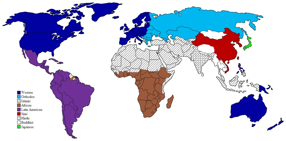
This world map shows the nine major civilisations proposed by the political scientist Samuel P. Huntington in his 1996 book The Clash of Civilizations and the Remaking of World Order: Western, Latin American, Orthodox, Islamic, Sinic, Buddhist, Japanese, Hindu and African.
Huntington first set out the idea in a 1993 article in Foreign Affairs. His argument was that after the Cold War the main source of conflict would be cultural and religious identity, not ideology or economics.
What the map shows
Each country is coloured according to the civilisation to which Huntington assigned it. Some countries, such as Ukraine, Nigeria and Sudan, were described by Huntington as 'cleft' countries because he considered they contained more than one civilisation. The boundaries between civilisations were described as the fault lines along which future conflicts would be most likely.
The approach was influential in debates about foreign policy, particularly after the attacks of 11 September 2001.
Why it is controversial
Critics argue that the map treats civilisations as uniform blocks, ignoring the diversity within them and the long history of exchange between them. Conflicts within civilisations, they note, are at least as common as those between them. The map is best read as a historical document of an influential theory, not as a description of fixed facts.
Responses and alternatives
The thesis drew many responses. The scholar Edward Said described it as a 'clash of ignorance', arguing that cultures are mixed and that blocs are political constructs. The economist Amartya Sen, in Identity and Violence, argued that people have many identities, and that reducing them to a single civilisation invites conflict. Whatever one's view, the map remains a useful example of how a theory can be turned into a persuasive picture.
Key facts
| Civilisation | Example regions |
|---|---|
| Western | North America, Western Europe, Australia |
| Latin American | Central and South America |
| Orthodox | Russia, Greece, Serbia |
| Islamic | North Africa, Middle East, Central Asia |
| Sinic | China |
| Hindu | India |
Questions about this map
Who proposed the theory?
Samuel P. Huntington.
When was it first published?
In a 1993 article, then as a book in 1996.
Do scholars accept it?
It is widely debated and often criticised for oversimplifying cultures.