Biafra Independent State Mapen
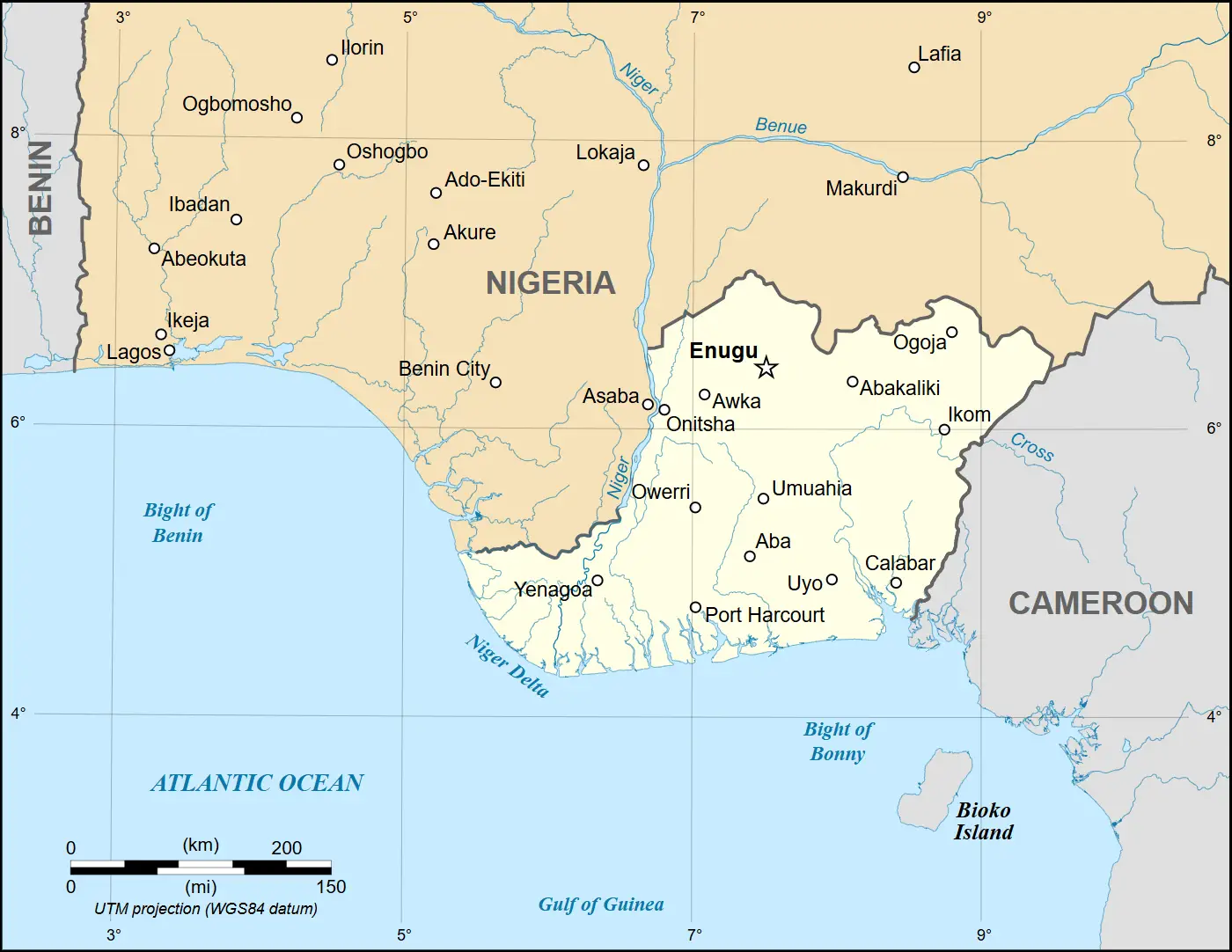
Click or tap the map to enlarge it.
Biafra Independent State Map
Key Takeaways:
- The Biafra Independent State Map depicts the regions of southeastern Nigeria that sought independence.
- This map represents a historical event during the Nigerian Civil War from 1967 to 1970.
- Biafra was a secessionist state, and its creation led to a bloody conflict with Nigeria.
- The map displays the boundaries, major cities, and geographical features of the Biafra region.
History:
The Biafra Independent State Map emerged during a turbulent period in Nigerian history. In 1967, the
predominantly Igbo region in southeastern Nigeria declared its independence from Nigeria, calling itself
Biafra. This secessionist movement was led by Lieutenant Colonel Odumegwu Ojukwu, who was the military governor
of the Eastern Region in Nigeria at the time.
The creation of Biafra led to the outbreak of the Nigerian Civil War, also known as the Biafran War, which lasted
from 1967 to 1970. The war was primarily fought between the Nigerian government, dominated by the Hausa and
Fulani ethnic groups, and the secessionist state of Biafra.
The Biafran territory was largely confined to the southeastern region of Nigeria, encompassing states such as
Abia, Anambra, Ebonyi, Enugu, and Imo. The Biafra Independent State Map accurately depicts the boundaries of the
secessionist state during this period.
Table of Relevant Facts:
| Year | Event |
|---|---|
| 1967 | The secessionist state of Biafra declared its independence from Nigeria. |
| 1967-1970 | The Nigerian Civil War took place, primarily between Nigeria and Biafra. |
| 1970 | Biafra surrendered, and the secessionist state was reintegrated into Nigeria. |
Unique Insights:
- The Biafra Independent State Map highlights the geopolitical divisions that arose during the Nigerian Civil
War. - It showcases the aspirations and struggles of the Igbo people in seeking self-determination.
- The map also brings attention to the devastating consequences of the war, including widespread famine and
economic collapse.
Frequently Asked Questions:
1. What was the reason behind the creation of Biafra?
The primary reason behind the creation of Biafra was the perception of political and economic marginalization
of the Igbo people in Nigeria. The Igbo region felt excluded from the power-sharing arrangement in the
Nigerian government, leading to demands for secession and the establishment of an independent state.
2. How long did the Nigerian Civil War last?
The Nigerian Civil War lasted for approximately three years, from 1967 to 1970.
3. What were the major consequences of the Nigerian Civil War?
The Nigerian Civil War resulted in significant human suffering, with estimates of hundreds of thousands to
millions of fatalities. The conflict also caused widespread famine and economic devastation in the Biafra
region.
4. Did Biafra gain international recognition as an independent state?
Biafra did not gain widespread international recognition as an independent state. While some countries and
organizations provided support to Biafra during the conflict, most nations maintained their allegiance to
Nigeria.
5. What led to the end of the Biafran secessionist movement?
The Biafran secessionist movement came to an end when Biafra surrendered to Nigerian forces in 1970. After the
surrender, the secessionist state was reintegrated into Nigeria.
6. Are there any ongoing separatist movements in Nigeria?
Yes, there are ongoing separatist movements in Nigeria, particularly in regions such as Biafra, the Niger
Delta, and the Oduduwa region. These movements often highlight perceived grievances and seek greater
autonomy or independence from the Nigerian state.
7. How does the Biafra Independent State Map contribute to our understanding of Nigerian history?
The Biafra Independent State Map provides a visual representation of a significant period in Nigerian history.
It helps us comprehend the complexity of ethnic and political divisions that have shaped the country, as
well as the human cost of conflicts.
LSI Keywords:
- Biafra Independent State
- Nigerian Civil War
- Igbo region
- Secessionist movement
- Biafran territory
- Geopolitical divisions
- Self-determination
- Political marginalization
- Economic devastation
- Separatist movements