Tornado Track Map 1999 Oklahoma Tornado Outbreak
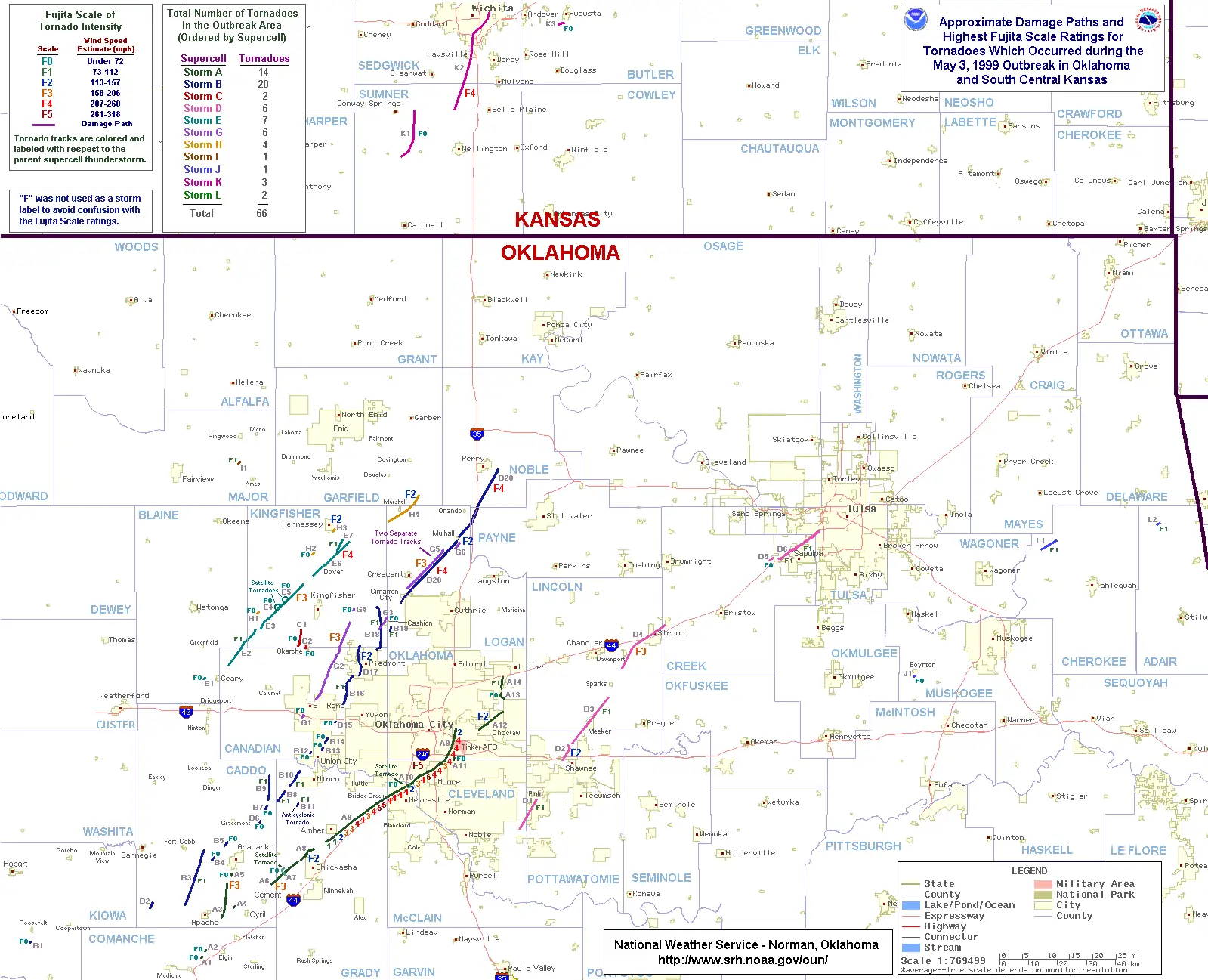
Click or tap the map to enlarge it.
Tornado Track Map 1999 Oklahoma Tornado Outbreak
Key Takeaways
- The 1999 Oklahoma Tornado Outbreak was one of the most devastating tornado events in US history.
- Multiple tornadoes occurred on May 3, 1999, resulting in significant damage and loss of life.
- A detailed map of the tornado tracks provides valuable information about the affected areas and the intensity of the tornadoes.
- Understanding the historical tornado patterns can help emergency management and urban planning to mitigate future damages.
History
The May 3, 1999, Oklahoma Tornado Outbreak was a catastrophic tornado event that struck central Oklahoma, particularly the Oklahoma City metropolitan area. This outbreak was one of the most destructive tornado outbreaks in US history, with numerous powerful tornadoes causing extensive damage and resulting in 46 fatalities.
The tornado outbreak began in the late afternoon of May 3, 1999, and continued into the night. Multiple supercells formed in the region, spawning several long-track tornadoes. One of the most notorious tornadoes was an F5 tornado that hit the suburbs of Oklahoma City, including parts of Moore and Bridge Creek. This tornado, known as the “Bridge Creek-Moore Tornado,” was responsible for the majority of the deaths and injuries.
Thanks to advancements in meteorological technology, scientists were able to accurately track the path and intensity of the tornadoes during the outbreak, allowing for the creation of detailed tornado track maps.
Unique Insights
- The 1999 Oklahoma Tornado Outbreak occurred during the peak of tornado season in the United States, which typically runs from late April to early June.
- The Bridge Creek-Moore Tornado traveled a path of approximately 38 miles and had a maximum width of 1.4 miles, making it an extremely large and powerful tornado.
- The tornado outbreak resulted in an estimated $1 billion in damages, making it one of the costliest tornado events in history.
- Lessons learned from the 1999 Oklahoma Tornado Outbreak led to significant improvements in tornado forecasting and warning systems, helping to save lives in future tornado events.
Table of Facts
| Tornado | Location | Path Length (miles) | Maximum Width (yards) | Fatalities |
|---|---|---|---|---|
| Bridge Creek-Moore Tornado | Bridge Creek to near Moore, Oklahoma | 38 | 1,320 | 36 |
| Choctaw-Nicoma Park Tornado | Choctaw to Nicoma Park, Oklahoma | 12 | 400 | 1 |
| Blackwell-Great Bend Tornado | Blackwell, Kansas to near Great Bend, Kansas | 79 | 900 | 2 |
| Andover, Kansas Tornado | Andover, Kansas | 37 | 1,320 | 11 |
Frequently Asked Questions (FAQ)
1. How many tornadoes occurred during the 1999 Oklahoma Tornado Outbreak?
A total of 66 tornadoes were recorded during the outbreak, with the most destructive one being the Bridge Creek-Moore Tornado.
2. What was the intensity of the Bridge Creek-Moore Tornado?
The Bridge Creek-Moore Tornado was rated as an F5 tornado, the highest level on the Fujita scale, indicating extremely violent winds exceeding 200 mph.
3. How many fatalities were recorded during the outbreak?
A total of 46 fatalities were reported as a result of the 1999 Oklahoma Tornado Outbreak.
4. Were there any significant advancements in tornado forecasting after this outbreak?
Yes, the 1999 Oklahoma Tornado Outbreak prompted advancements in tornado forecasting and warning systems, leading to improved accuracy and earlier warnings.
5. Is the Bridge Creek-Moore Tornado the deadliest tornado in Oklahoma history?
No, the deadliest tornado in Oklahoma history is the 2013 Moore Tornado, which caused 24 deaths.
6. How much damage did the tornado outbreak cause?
The tornado outbreak resulted in an estimated $1 billion in damages.
7. How did the 1999 Oklahoma Tornado Outbreak impact future emergency management strategies?
The outbreak led to improved emergency management strategies, including better coordination between meteorologists, emergency responders, and local communities.